Sahan geodata
Sahan (East Nusa Tenggara) is a seat of a fourth-order administrative division; located in Indonesia in Asia/Makassar (GMT+8) time zone. In our database, there are 407 cities with bigger population. Compared to other cities in Indonesia, 96.3% of cities are located further ↑North; 97.4% of cities are located further ←West and 72.9% of cities have lower elevation than Sahan. Note1


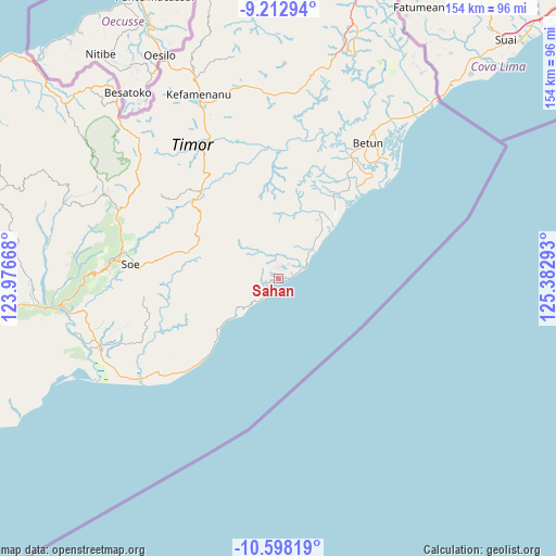
Sahan GPS coordinates[2]
9° 54' 22.68" South, 124° 40' 47.28" East
| Map corner | latitude | longitude |
|---|---|---|
| Upper-left | -9.21294°, | 123.97668° |
| Center: | -9.9063°, | 124.6798° |
| Lower-right: | -10.59819°, | 125.38293° |
| Map W x H: | 154×154 km | = 95.7×95.7mi |
| max Lat: | 5.88969° ⇑96.3% North |
| Sahan: | -9.9063° |
| min Lat: | ⇓3.7% South -10.934° |
| min Long | Sahan | max Long |
| 95.1345° | 124.6798° | 140.9419° |
| W 97.4%⇐ | ⇒2.6% E |
Elevation
Elevation of Sahan is 333 m = 1093 ft, and this is 103.3 m = 339 ft above average elevation for this country.
| Max E: |
3185 m = 10449 ft | 27.1% |
| Sahan | 333 m 1093 ft | |
| Avg. | 229.7 m = 754 ft | |
Min E: |
-1 m = -3 ft | 72.9% |
See also: Indonesia elevation on elevation.city.
Geographical zone
Sahan is located in South Torrid zone (between Equator and Tropic of Capricorn). Distance of Equator is 1101.5 km =684.4 mi to North.| Distance of | km | miles | from Sahan |
|---|---|---|---|
| Equator | 1101.5 | 684.4 | to North |
| Tropic Capricorn | 1504.4 | 934.8 | to South |
| Antarctic Circle | 6299.7 | 3914.5 | to South |
| South Pole | 8905.6 | 5533.7 | to South |


Nearby cities:
15 places around Sahan: (largest is in red/bold)
• Ayofanu
10.3 km =6.4 mi,  289°
289°
• Fatuulan
7.2 km =4.5 mi,  269°
269°
• Haumeni
3.5 km =2.2 mi,  312°
312°
• Koana
8.7 km =5.4 mi,  8°
8°
• Kualeu
5.8 km =3.6 mi,  328°
328°
• Maemutip
3.2 km =2 mi,  357°
357°
• Nunleu
6.7 km =4.2 mi,  295°
295°
• Nunutoko
6.9 km =4.3 mi,  227°
227°
• Oebubun
10.1 km =6.3 mi, 301°
• Oenopu
4.7 km =2.9 mi,  35°
35°
• Oetotom
8.3 km =5.2 mi,  32°
32°
• Op
3.7 km =2.3 mi,  254°
254°
• Putun
3.4 km =2.1 mi,  338°
338°
• Sbo’o
7.9 km =4.9 mi, 339°
• Tene
9.1 km =5.7 mi,  323°
323°
Sources, notices
• [Note1] Compared only with cities in Indonesia existing in our database
• [Src1] Map data: © OpenStreetMap contributors (CC-BY-SA)
• [Src2] Other city data from geonames.org with taken over terms of usage.
• [Src3] Geographical zone / Annual Mean Temperature by Robert A. Rohde @ Wikipedia
