Sbo’o geodata
Sbo’o (East Nusa Tenggara) is a seat of a fourth-order administrative division; located in Indonesia in Asia/Makassar (GMT+8) time zone. In our database, there are 407 cities with bigger population. Compared to other cities in Indonesia, 95.6% of cities are located further ↑North; 97.3% of cities are located further ←West and 88.9% of cities have lower elevation than Sbo’o. Note1


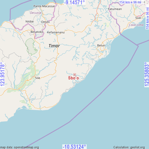
Sbo’o GPS coordinates[2]
9° 50' 21.12" South, 124° 39' 17.64" East
| Map corner | latitude | longitude |
|---|---|---|
| Upper-left | -9.14571°, | 123.95178° |
| Center: | -9.8392°, | 124.6549° |
| Lower-right: | -10.53124°, | 125.35803° |
| Map W x H: | 154.1×154.1 km | = 95.8×95.8mi |
| max Lat: | 5.88969° ⇑95.6% North |
| Sbo’o: | -9.8392° |
| min Lat: | ⇓4.4% South -10.934° |
| min Long | Sbo’o | max Long |
| 95.1345° | 124.6549° | 140.9419° |
| W 97.3%⇐ | ⇒2.7% E |
Elevation
Elevation of Sbo’o is 604 m = 1982 ft, and this is 374.3 m = 1228 ft above average elevation for this country.
| Max E: |
3185 m = 10449 ft | 11.1% |
| Sbo’o | 604 m 1982 ft | |
| Avg. | 229.7 m = 754 ft | |
Min E: |
-1 m = -3 ft | 88.9% |
See also: Indonesia elevation on elevation.city.
Geographical zone
Sbo’o is located in South Torrid zone (between Equator and Tropic of Capricorn). Distance of Equator is 1094 km =679.8 mi to North.| Distance of | km | miles | from Sbo’o |
|---|---|---|---|
| Equator | 1094 | 679.8 | to North |
| Tropic Capricorn | 1511.9 | 939.5 | to South |
| Antarctic Circle | 6307.2 | 3919.1 | to South |
| South Pole | 8913 | 5538.3 | to South |


Nearby cities:
15 places around Sbo’o: (largest is in red/bold)
• Fatuhilik
6.8 km =4.2 mi,  305°
305°
• Haumeni
5.1 km =3.2 mi,  178°
178°
• Koana
4.1 km =2.5 mi,  74°
74°
• Kualeu
2.5 km =1.6 mi,  185°
185°
• Linakelopu
6.7 km =4.2 mi,  302°
302°
• Maemutip
5 km =3.1 mi,  148°
148°
• Malla
6.7 km =4.2 mi,  40°
40°
• Nenotes
4.3 km =2.7 mi,  33°
33°
• Nunleu
5.6 km =3.5 mi,  216°
216°
• Oebubun
6.3 km =3.9 mi,  249°
249°
• Oenopu
6.6 km =4.1 mi,  123°
123°
• Oetotom
7.2 km =4.5 mi,  93°
93°
• Putun
4.6 km =2.9 mi,  161°
161°
• Sunu
2.6 km =1.6 mi,  325°
325°
• Tene
2.7 km =1.7 mi,  267°
267°
Sources, notices
• [Note1] Compared only with cities in Indonesia existing in our database
• [Src1] Map data: © OpenStreetMap contributors (CC-BY-SA)
• [Src2] Other city data from geonames.org with taken over terms of usage.
• [Src3] Geographical zone / Annual Mean Temperature by Robert A. Rohde @ Wikipedia
