Maemutip geodata
Maemutip (East Nusa Tenggara) is a seat of a fourth-order administrative division; located in Indonesia in Asia/Makassar (GMT+8) time zone. In our database, there are 407 cities with bigger population. Compared to other cities in Indonesia, 96.2% of cities are located further ↑North; 97.4% of cities are located further ←West and 96.1% of cities have lower elevation than Maemutip. Note1


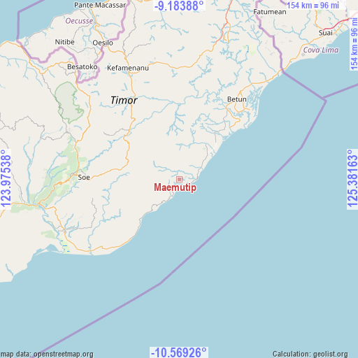
Maemutip GPS coordinates[2]
9° 52' 38.28" South, 124° 40' 42.6" East
| Map corner | latitude | longitude |
|---|---|---|
| Upper-left | -9.18388°, | 123.97538° |
| Center: | -9.8773°, | 124.6785° |
| Lower-right: | -10.56926°, | 125.38163° |
| Map W x H: | 154×154 km | = 95.7×95.7mi |
| max Lat: | 5.88969° ⇑96.2% North |
| Maemutip: | -9.8773° |
| min Lat: | ⇓3.8% South -10.934° |
| min Long | Maemutip | max Long |
| 95.1345° | 124.6785° | 140.9419° |
| W 97.4%⇐ | ⇒2.6% E |
Elevation
Elevation of Maemutip is 883 m = 2897 ft, and this is 653.3 m = 2143 ft above average elevation for this country.
| Max E: |
3185 m = 10449 ft | 3.9% |
| Maemutip | 883 m 2897 ft | |
| Avg. | 229.7 m = 754 ft | |
Min E: |
-1 m = -3 ft | 96.1% |
See also: Indonesia elevation on elevation.city.
Geographical zone
Maemutip is located in South Torrid zone (between Equator and Tropic of Capricorn). Distance of Equator is 1098.3 km =682.5 mi to North.| Distance of | km | miles | from Maemutip |
|---|---|---|---|
| Equator | 1098.3 | 682.5 | to North |
| Tropic Capricorn | 1507.7 | 936.8 | to South |
| Antarctic Circle | 6302.9 | 3916.4 | to South |
| South Pole | 8908.8 | 5535.7 | to South |


Nearby cities:
15 places around Maemutip: (largest is in red/bold)
• Fatuulan
7.8 km =4.8 mi,  244°
244°
• Haumeni
2.6 km =1.6 mi,  250°
250°
• Koana
5.5 km =3.4 mi,  14°
14°
• Kualeu
3.3 km =2.1 mi,  301°
301°
• Nenotes
7.8 km =4.8 mi,  358°
358°
• Nunleu
5.9 km =3.7 mi,  267°
267°
• Oebubun
8.7 km =5.4 mi,  283°
283°
• Oenopu
2.9 km =1.8 mi,  78°
78°
• Oetotom
6 km =3.7 mi,  50°
50°
• Op
5.4 km =3.4 mi,  219°
219°
• Putun
1.1 km =0.7 mi, 265°
• Sahan
3.2 km =2 mi,  177°
177°
• Sbo’o
5 km =3.1 mi,  328°
328°
• Sunu
7.6 km =4.7 mi, 327°
• Tene
6.7 km =4.2 mi,  308°
308°
Sources, notices
• [Note1] Compared only with cities in Indonesia existing in our database
• [Src1] Map data: © OpenStreetMap contributors (CC-BY-SA)
• [Src2] Other city data from geonames.org with taken over terms of usage.
• [Src3] Geographical zone / Annual Mean Temperature by Robert A. Rohde @ Wikipedia
