Malla geodata
Malla (East Nusa Tenggara) is a seat of a fourth-order administrative division; located in Indonesia in Asia/Makassar (GMT+8) time zone. In our database, there are 407 cities with bigger population. Compared to other cities in Indonesia, 95.4% of cities are located further ↑North; 97.5% of cities are located further ←West and 87.1% of cities have lower elevation than Malla. Note1


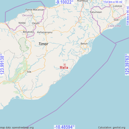
Malla GPS coordinates[2]
9° 47' 37.68" South, 124° 41' 40.2" East
| Map corner | latitude | longitude |
|---|---|---|
| Upper-left | -9.10022°, | 123.99138° |
| Center: | -9.7938°, | 124.6945° |
| Lower-right: | -10.48594°, | 125.39763° |
| Map W x H: | 154.1×154.1 km | = 95.8×95.8mi |
| max Lat: | 5.88969° ⇑95.4% North |
| Malla: | -9.7938° |
| min Lat: | ⇓4.6% South -10.934° |
| min Long | Malla | max Long |
| 95.1345° | 124.6945° | 140.9419° |
| W 97.5%⇐ | ⇒2.5% E |
Elevation
Elevation of Malla is 558 m = 1831 ft, and this is 328.3 m = 1077 ft above average elevation for this country.
| Max E: |
3185 m = 10449 ft | 12.9% |
| Malla | 558 m 1831 ft | |
| Avg. | 229.7 m = 754 ft | |
Min E: |
-1 m = -3 ft | 87.1% |
See also: Indonesia elevation on elevation.city.
Geographical zone
Malla is located in South Torrid zone (between Equator and Tropic of Capricorn). Distance of Equator is 1089 km =676.7 mi to North.| Distance of | km | miles | from Malla |
|---|---|---|---|
| Equator | 1089 | 676.7 | to North |
| Tropic Capricorn | 1517 | 942.6 | to South |
| Antarctic Circle | 6312.2 | 3922.2 | to South |
| South Pole | 8918.1 | 5541.4 | to South |


Nearby cities:
15 places around Malla: (largest is in red/bold)
• Fotilo
6.3 km =3.9 mi,  359°
359°
• Koana
4 km =2.5 mi,  185°
185°
• Kualeu
8.8 km =5.5 mi,  211°
211°
• Manufui
3.5 km =2.2 mi,  83°
83°
• Nenotes
2.5 km =1.6 mi,  232°
232°
• Noebana
4.7 km =2.9 mi,  300°
300°
• Oefenu
4.7 km =2.9 mi,  331°
331°
• Oeleu
7.4 km =4.6 mi,  43°
43°
• Oenopu
8.8 km =5.5 mi,  172°
172°
• Oesoot
8.1 km =5 mi,  21°
21°
• Oetotom
6.2 km =3.9 mi,  152°
152°
• Poli
3 km =1.9 mi, 17°
• Sbo’o
6.7 km =4.2 mi,  220°
220°
• Sunu
6.5 km =4 mi,  243°
243°
• Tene
8.7 km =5.4 mi, 233°
Sources, notices
• [Note1] Compared only with cities in Indonesia existing in our database
• [Src1] Map data: © OpenStreetMap contributors (CC-BY-SA)
• [Src2] Other city data from geonames.org with taken over terms of usage.
• [Src3] Geographical zone / Annual Mean Temperature by Robert A. Rohde @ Wikipedia
