Nenotes geodata
Nenotes (East Nusa Tenggara) is a seat of a fourth-order administrative division; located in Indonesia in Asia/Makassar (GMT+8) time zone. In our database, there are 407 cities with bigger population. Compared to other cities in Indonesia, 95.5% of cities are located further ↑North; 97.4% of cities are located further ←West and 93.6% of cities have lower elevation than Nenotes. Note1


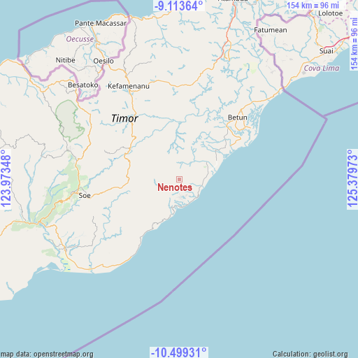
Nenotes GPS coordinates[2]
9° 48' 25.92" South, 124° 40' 35.76" East
| Map corner | latitude | longitude |
|---|---|---|
| Upper-left | -9.11364°, | 123.97348° |
| Center: | -9.8072°, | 124.6766° |
| Lower-right: | -10.49931°, | 125.37973° |
| Map W x H: | 154.1×154.1 km | = 95.8×95.8mi |
| max Lat: | 5.88969° ⇑95.5% North |
| Nenotes: | -9.8072° |
| min Lat: | ⇓4.5% South -10.934° |
| min Long | Nenotes | max Long |
| 95.1345° | 124.6766° | 140.9419° |
| W 97.4%⇐ | ⇒2.6% E |
Elevation
Elevation of Nenotes is 751 m = 2464 ft, and this is 521.3 m = 1710 ft above average elevation for this country.
| Max E: |
3185 m = 10449 ft | 6.4% |
| Nenotes | 751 m 2464 ft | |
| Avg. | 229.7 m = 754 ft | |
Min E: |
-1 m = -3 ft | 93.6% |
See also: Indonesia elevation on elevation.city.
Geographical zone
Nenotes is located in South Torrid zone (between Equator and Tropic of Capricorn). Distance of Equator is 1090.5 km =677.6 mi to North.| Distance of | km | miles | from Nenotes |
|---|---|---|---|
| Equator | 1090.5 | 677.6 | to North |
| Tropic Capricorn | 1515.5 | 941.7 | to South |
| Antarctic Circle | 6310.7 | 3921.3 | to South |
| South Pole | 8916.6 | 5540.5 | to South |


Nearby cities:
15 places around Nenotes: (largest is in red/bold)
• Fotilo
8 km =5 mi,  13°
13°
• Koana
2.9 km =1.8 mi,  146°
146°
• Kualeu
6.6 km =4.1 mi,  203°
203°
• Maemutip
7.8 km =4.8 mi,  178°
178°
• Malla
2.5 km =1.6 mi,  52°
52°
• Manufui
5.8 km =3.6 mi,  70°
70°
• Noebana
4.4 km =2.7 mi,  331°
331°
• Oefenu
5.6 km =3.5 mi,  356°
356°
• Oenopu
7.9 km =4.9 mi,  156°
156°
• Oetotom
6.3 km =3.9 mi,  129°
129°
• Poli
5.2 km =3.2 mi,  33°
33°
• Putun
7.9 km =4.9 mi,  186°
186°
• Sbo’o
4.3 km =2.7 mi,  213°
213°
• Sunu
4.1 km =2.5 mi,  250°
250°
• Tene
6.2 km =3.9 mi,  233°
233°
Sources, notices
• [Note1] Compared only with cities in Indonesia existing in our database
• [Src1] Map data: © OpenStreetMap contributors (CC-BY-SA)
• [Src2] Other city data from geonames.org with taken over terms of usage.
• [Src3] Geographical zone / Annual Mean Temperature by Robert A. Rohde @ Wikipedia
