Leuweheq geodata
Leuweheq (East Nusa Tenggara) is a seat of a fourth-order administrative division; located in Indonesia in Asia/Makassar (GMT+8) time zone. In our database, there are 407 cities with bigger population. Compared to other cities in Indonesia, 73.3% of cities are located further ↑North; 93.5% of cities are located further ←West and 68.4% of cities have lower elevation than Leuweheq. Note1


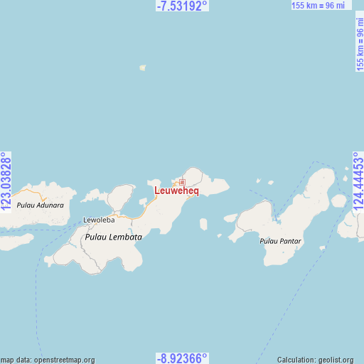
Leuweheq GPS coordinates[2]
8° 13' 42.24" South, 123° 44' 29.04" East
| Map corner | latitude | longitude |
|---|---|---|
| Upper-left | -7.53192°, | 123.03828° |
| Center: | -8.2284°, | 123.7414° |
| Lower-right: | -8.92366°, | 124.44453° |
| Map W x H: | 154.7×154.8 km | = 96.1×96.2mi |
| max Lat: | 5.88969° ⇑73.3% North |
| Leuweheq: | -8.2284° |
| min Lat: | ⇓26.7% South -10.934° |
| min Long | Leuweheq | max Long |
| 95.1345° | 123.7414° | 140.9419° |
| W 93.5%⇐ | ⇒6.5% E |
Elevation
Elevation of Leuweheq is 269 m = 883 ft, and this is 39.3 m = 129 ft above average elevation for this country.
| Max E: |
3185 m = 10449 ft | 31.6% |
| Leuweheq | 269 m 883 ft | |
| Avg. | 229.7 m = 754 ft | |
Min E: |
-1 m = -3 ft | 68.4% |
See also: Indonesia elevation on elevation.city.
Geographical zone
Leuweheq is located in South Torrid zone (between Equator and Tropic of Capricorn). Distance of Equator is 914.9 km =568.5 mi to North.| Distance of | km | miles | from Leuweheq |
|---|---|---|---|
| Equator | 914.9 | 568.5 | to North |
| Tropic Capricorn | 1691 | 1050.7 | to South |
| Antarctic Circle | 6486.3 | 4030.4 | to South |
| South Pole | 9092.1 | 5649.6 | to South |


Nearby cities:
15 places around Leuweheq: (largest is in red/bold)
• Aliuroba
5.4 km =3.4 mi,  101°
101°
• Atarodangkedang
3.3 km =2.1 mi,  7°
7°
• Atarodangwautu
5.3 km =3.3 mi,  21°
21°
• Balauring
3.9 km =2.4 mi,  261°
261°
• Bungalaleng
4.3 km =2.7 mi, 17°
• Dolulolong
2.5 km =1.6 mi,  316°
316°
• Hadingrobi
5.1 km =3.2 mi, 104°
• Hoelea
1.4 km =0.9 mi,  0°
0°
• Leubatang
2.8 km =1.7 mi,  139°
139°
• Leuwayang
3.6 km =2.2 mi, 12°
• Meluwiting
1.6 km =1 mi,  159°
159°
• Orolaleng
3.2 km =2 mi,  125°
125°
• Peuara
2 km =1.2 mi,  150°
150°
• Riangbao
4.6 km =2.9 mi,  111°
111°
• Werangrae
6 km =3.7 mi, 24°
Sources, notices
• [Note1] Compared only with cities in Indonesia existing in our database
• [Src1] Map data: © OpenStreetMap contributors (CC-BY-SA)
• [Src2] Other city data from geonames.org with taken over terms of usage.
• [Src3] Geographical zone / Annual Mean Temperature by Robert A. Rohde @ Wikipedia
