Peuara geodata
Peuara (East Nusa Tenggara) is a seat of a fourth-order administrative division; located in Indonesia in Asia/Makassar (GMT+8) time zone. In our database, there are 407 cities with bigger population. Compared to other cities in Indonesia, 74.1% of cities are located further ↑North; 93.6% of cities are located further ←West and 78.7% of cities have lower elevation than Peuara. Note1


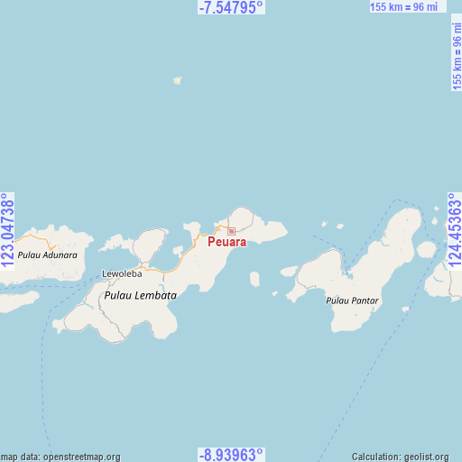
Peuara GPS coordinates[2]
8° 14' 39.84" South, 123° 45' 1.8" East
| Map corner | latitude | longitude |
|---|---|---|
| Upper-left | -7.54795°, | 123.04738° |
| Center: | -8.2444°, | 123.7505° |
| Lower-right: | -8.93963°, | 124.45363° |
| Map W x H: | 154.7×154.7 km | = 96.1×96.1mi |
| max Lat: | 5.88969° ⇑74.1% North |
| Peuara: | -8.2444° |
| min Lat: | ⇓25.9% South -10.934° |
| min Long | Peuara | max Long |
| 95.1345° | 123.7505° | 140.9419° |
| W 93.6%⇐ | ⇒6.4% E |
Elevation
Elevation of Peuara is 408 m = 1339 ft, and this is 178.3 m = 585 ft above average elevation for this country.
| Max E: |
3185 m = 10449 ft | 21.3% |
| Peuara | 408 m 1339 ft | |
| Avg. | 229.7 m = 754 ft | |
Min E: |
-1 m = -3 ft | 78.7% |
See also: Indonesia elevation on elevation.city.
Geographical zone
Peuara is located in South Torrid zone (between Equator and Tropic of Capricorn). Distance of Equator is 916.7 km =569.6 mi to North.| Distance of | km | miles | from Peuara |
|---|---|---|---|
| Equator | 916.7 | 569.6 | to North |
| Tropic Capricorn | 1689.2 | 1049.6 | to South |
| Antarctic Circle | 6484.5 | 4029.3 | to South |
| South Pole | 9090.4 | 5648.5 | to South |


Nearby cities:
15 places around Peuara: (largest is in red/bold)
• Aliuroba
4.4 km =2.7 mi,  81°
81°
• Atarodangkedang
5 km =3.1 mi,  353°
353°
• Atarodangwautu
6.8 km =4.2 mi,  7°
7°
• Balauring
5 km =3.1 mi,  283°
283°
• Bungalaleng
5.9 km =3.7 mi,  2°
2°
• Dolulolong
4.5 km =2.8 mi,  323°
323°
• Hadingrobi
4 km =2.5 mi, 82°
• Hoelea
3.4 km =2.1 mi,  342°
342°
• Leubatang
0.9 km =0.6 mi,  113°
113°
• Leutubung Satu
6.7 km =4.2 mi,  74°
74°
• Leuwayang
5.3 km =3.3 mi,  357°
357°
• Leuweheq
2 km =1.2 mi,  330°
330°
• Meluwiting
0.6 km =0.4 mi,  305°
305°
• Orolaleng
1.7 km =1.1 mi,  93°
93°
• Riangbao
3.3 km =2.1 mi, 89°
Sources, notices
• [Note1] Compared only with cities in Indonesia existing in our database
• [Src1] Map data: © OpenStreetMap contributors (CC-BY-SA)
• [Src2] Other city data from geonames.org with taken over terms of usage.
• [Src3] Geographical zone / Annual Mean Temperature by Robert A. Rohde @ Wikipedia
