Atarodangwautu geodata
Atarodangwautu (East Nusa Tenggara) is a seat of a fourth-order administrative division; located in Indonesia in Asia/Makassar (GMT+8) time zone. In our database, there are 407 cities with bigger population. Compared to other cities in Indonesia, 70.6% of cities are located further ↑North; 93.6% of cities are located further ←West and 61.1% of cities have higher elevation than Atarodangwautu. Note1


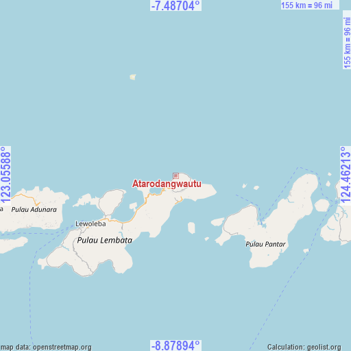
Atarodangwautu GPS coordinates[2]
8° 11' 0.96" South, 123° 45' 32.4" East
| Map corner | latitude | longitude |
|---|---|---|
| Upper-left | -7.48704°, | 123.05588° |
| Center: | -8.1836°, | 123.759° |
| Lower-right: | -8.87894°, | 124.46213° |
| Map W x H: | 154.8×154.8 km | = 96.2×96.2mi |
| max Lat: | 5.88969° ⇑70.6% North |
| Atarodangwautu: | -8.1836° |
| min Lat: | ⇓29.4% South -10.934° |
| min Long | Atarodangwautu | max Long |
| 95.1345° | 123.759° | 140.9419° |
| W 93.6%⇐ | ⇒6.4% E |
Elevation
Elevation of Atarodangwautu is 55 m = 180 ft, and this is 174.7 m = 573 ft below average elevation for this country.
| Max E: |
3185 m = 10449 ft | 61.1% |
| Avg. | 229.7 m = 754 ft | |
| Atarodangwautu | 55 m = 180 ft | |
Min E: |
-1 m = -3 ft | 38.9% |
See also: Indonesia elevation on elevation.city.
Geographical zone
Atarodangwautu is located in South Torrid zone (between Equator and Tropic of Capricorn). Distance of Equator is 909.9 km =565.4 mi to North.| Distance of | km | miles | from Atarodangwautu |
|---|---|---|---|
| Equator | 909.9 | 565.4 | to North |
| Tropic Capricorn | 1696 | 1053.8 | to South |
| Antarctic Circle | 6491.2 | 4033.4 | to South |
| South Pole | 9097.1 | 5652.7 | to South |


Nearby cities:
15 places around Atarodangwautu: (largest is in red/bold)
• Atarodangkedang
2.3 km =1.4 mi,  221°
221°
• Bareng
2.1 km =1.3 mi,  55°
55°
• Bungalaleng
1.1 km =0.7 mi, 217°
• Buriwutung
5.5 km =3.4 mi,  89°
89°
• Dolulolong
4.8 km =3 mi,  228°
228°
• Hoelea
4.1 km =2.5 mi,  208°
208°
• Leuwayang
1.9 km =1.2 mi, 217°
• Leuweheq
5.3 km =3.3 mi,  201°
201°
• Leuwohung
3.8 km =2.4 mi,  72°
72°
• Lewutung
5.9 km =3.7 mi,  96°
96°
• Meluwiting
6.6 km =4.1 mi,  192°
192°
• Peuara
6.8 km =4.2 mi, 187°
• Peuhaq
4.3 km =2.7 mi,  80°
80°
• Wairiang
6.6 km =4.1 mi, 98°
• Werangrae
0.7 km =0.4 mi,  47°
47°
Sources, notices
• [Note1] Compared only with cities in Indonesia existing in our database
• [Src1] Map data: © OpenStreetMap contributors (CC-BY-SA)
• [Src2] Other city data from geonames.org with taken over terms of usage.
• [Src3] Geographical zone / Annual Mean Temperature by Robert A. Rohde @ Wikipedia
