Oli geodata
Oli (East Nusa Tenggara) is a seat of a fourth-order administrative division; located in Indonesia in Asia/Makassar (GMT+8) time zone. In our database, there are 407 cities with bigger population. Compared to other cities in Indonesia, 99.8% of cities are located further ↑North; 89.1% of cities are located further ←West and 78.9% of cities have higher elevation than Oli. Note1


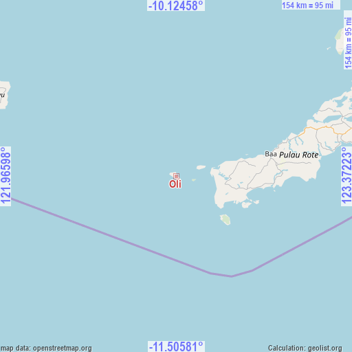
Oli GPS coordinates[2]
10° 48' 57.564" South, 122° 40' 8.76" East
| Map corner | latitude | longitude |
|---|---|---|
| Upper-left | -10.12458°, | 121.96598° |
| Center: | -10.81599°, | 122.6691° |
| Lower-right: | -11.50581°, | 123.37223° |
| Map W x H: | 153.6×153.6 km | = 95.4×95.4mi |
| max Lat: | 5.88969° ⇑99.8% North |
| Oli: | -10.81599° |
| min Lat: | ⇓0.2% South -10.934° |
| min Long | Oli | max Long |
| 95.1345° | 122.6691° | 140.9419° |
| W 89.1%⇐ | ⇒10.9% E |
Elevation
Elevation of Oli is 20 m = 66 ft, and this is 209.7 m = 688 ft below average elevation for this country.
| Max E: |
3185 m = 10449 ft | 78.9% |
| Avg. | 229.7 m = 754 ft | |
| Oli | 20 m = 66 ft | |
Min E: |
-1 m = -3 ft | 21.1% |
See also: Indonesia elevation on elevation.city.
Geographical zone
Oli is located in South Torrid zone (between Equator and Tropic of Capricorn). Distance of Equator is 1202.6 km =747.3 mi to North.| Distance of | km | miles | from Oli |
|---|---|---|---|
| Equator | 1202.6 | 747.3 | to North |
| Tropic Capricorn | 1403.3 | 872 | to South |
| Antarctic Circle | 6198.5 | 3851.6 | to South |
| South Pole | 8804.4 | 5470.8 | to South |


Nearby cities:
15 places around Oli: (largest is in red/bold)
• Aduoen
20.6 km =12.8 mi,  83°
83°
• Faeanak Dua
30.1 km =18.7 mi,  85°
85°
• Kotafeuk
30.8 km =19.1 mi, 83°
• Lalukoen Dua
28.6 km =17.8 mi,  100°
100°
• Leteki
27 km =16.8 mi,  110°
110°
• Lidor
27.1 km =16.8 mi, 96°
• Mbueaian
17.5 km =10.9 mi, 86°
• Nemberala
18.8 km =11.7 mi, 114°
• Oebou
31.2 km =19.4 mi, 107°
• Oelaba
27.4 km =17 mi, 75°
• Oemau
23.6 km =14.7 mi,  123°
123°
• Olo
21.6 km =13.4 mi, 99°
• Roioen
31.1 km =19.3 mi, 95°
• Sedeoen
18.9 km =11.7 mi, 111°
• Tunggaoen Timur
21.1 km =13.1 mi, 124°
Sources, notices
• [Note1] Compared only with cities in Indonesia existing in our database
• [Src1] Map data: © OpenStreetMap contributors (CC-BY-SA)
• [Src2] Other city data from geonames.org with taken over terms of usage.
• [Src3] Geographical zone / Annual Mean Temperature by Robert A. Rohde @ Wikipedia
