Bontang Baru geodata
Bontang Baru (East Kalimantan) is a seat of a third-order administrative division; located in Indonesia in Asia/Makassar (GMT+8) time zone. In our database, there are 407 cities with bigger population. Compared to other cities in Indonesia, 95.2% of cities are located further ↓South; 79.1% of cities are located further ←West and 86.4% of cities have higher elevation than Bontang Baru. Note1


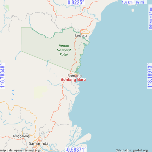
Bontang Baru GPS coordinates[2]
0° 7' 9.84" North, 117° 29' 11.76" East
| Map corner | latitude | longitude |
|---|---|---|
| Upper-left | 0.8225°, | 116.78348° |
| Center: | 0.1194°, | 117.4866° |
| Lower-right: | -0.58371°, | 118.18973° |
| Map W x H: | 156.4×156.4 km | = 97.2×97.2mi |
| max Lat: | 5.88969° ⇑4.8% North |
| Bontang Baru: | 0.1194° |
| min Lat: | ⇓95.2% South -10.934° |
| min Long | Bontang Baru | max Long |
| 95.1345° | 117.4866° | 140.9419° |
| W 79.1%⇐ | ⇒20.9% E |
Elevation
Elevation of Bontang Baru is 13 m = 43 ft, and this is 216.7 m = 711 ft below average elevation for this country.
| Max E: |
3185 m = 10449 ft | 86.4% |
| Avg. | 229.7 m = 754 ft | |
| Bontang Baru | 13 m = 43 ft | |
Min E: |
-1 m = -3 ft | 13.6% |
See also: Indonesia elevation on elevation.city.
Geographical zone
Bontang Baru is located in North Torrid zone (between Equator and Tropic of Cancer). Distance of Equator is 13.3 km =8.3 mi to South.| Distance of | km | miles | from Bontang Baru |
|---|---|---|---|
| North Pole | 9993.8 | 6209.9 | to North |
| Arctic Circle | 7387.9 | 4590.6 | to North |
| Tropic Cancer | 2592.6 | 1611 | to North |
| Equator | 13.3 | 8.3 | to South |


Nearby cities:
15 places around Bontang Baru: (largest is in red/bold)
• Anggana
79.9 km =49.6 mi,  196°
196°
• Balikpapan
170.7 km =106.1 mi,  205°
205°
• Bontang
1.5 km =0.9 mi,  354°
354°
• City of Balikpapan
165.1 km =102.6 mi, 203°
• Handilenam
108.2 km =67.2 mi,  194°
194°
• Loa Janan
89.4 km =55.6 mi, 209°
• Loakulu
87.8 km =54.6 mi,  216°
216°
• Muarabadak
52.6 km =32.7 mi, 186°
• Palaran
83.3 km =51.8 mi, 202°
• Samarinda
77.8 km =48.3 mi, 209°
• Samboja
137.7 km =85.6 mi, 201°
• Sangasangadalam
91.3 km =56.7 mi, 197°
• Sangatta
43.1 km =26.8 mi,  6°
6°
• Sangkulirang
110 km =68.4 mi,  29°
29°
• Sebulu
69.7 km =43.3 mi,  231°
231°
Sources, notices
• [Note1] Compared only with cities in Indonesia existing in our database
• [Src1] Map data: © OpenStreetMap contributors (CC-BY-SA)
• [Src2] Other city data from geonames.org with taken over terms of usage.
• [Src3] Geographical zone / Annual Mean Temperature by Robert A. Rohde @ Wikipedia
