Sebulu geodata
Sebulu (East Kalimantan) is a seat of a third-order administrative division; located in Indonesia in Asia/Makassar (GMT+8) time zone. In our database, there are 407 cities with bigger population. Compared to other cities in Indonesia, 94.9% of cities are located further ↓South; 78.4% of cities are located further ←West and 93.7% of cities have higher elevation than Sebulu. Note1


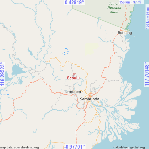
Sebulu GPS coordinates[2]
0° 16' 26.148" South, 116° 59' 54.06" East
| Map corner | latitude | longitude |
|---|---|---|
| Upper-left | 0.42919°, | 116.29523° |
| Center: | -0.27393°, | 116.99835° |
| Lower-right: | -0.97701°, | 117.70148° |
| Map W x H: | 156.4×156.4 km | = 97.2×97.2mi |
| max Lat: | 5.88969° ⇑5.1% North |
| Sebulu: | -0.27393° |
| min Lat: | ⇓94.9% South -10.934° |
| min Long | Sebulu | max Long |
| 95.1345° | 116.99835° | 140.9419° |
| W 78.4%⇐ | ⇒21.6% E |
Elevation
Elevation of Sebulu is 8 m = 26 ft, and this is 221.7 m = 727 ft below average elevation for this country.
| Max E: |
3185 m = 10449 ft | 93.7% |
| Avg. | 229.7 m = 754 ft | |
| Sebulu | 8 m = 26 ft | |
Min E: |
-1 m = -3 ft | 6.3% |
See also: Indonesia elevation on elevation.city.
Geographical zone
Sebulu is located in South Torrid zone (between Equator and Tropic of Capricorn). Distance of Equator is 30.5 km =19 mi to North.| Distance of | km | miles | from Sebulu |
|---|---|---|---|
| Equator | 30.5 | 19 | to North |
| Tropic Capricorn | 2575.5 | 1600.3 | to South |
| Antarctic Circle | 7370.7 | 4579.9 | to South |
| South Pole | 9976.6 | 6199.2 | to South |


Nearby cities:
15 places around Sebulu: (largest is in red/bold)
• Anggana
45.8 km =28.5 mi,  136°
136°
• Balikpapan
112.1 km =69.7 mi,  189°
189°
• Bontang
70.5 km =43.8 mi,  50°
50°
• Bontang Baru
69.7 km =43.3 mi, 51°
• City of Balikpapan
108.3 km =67.3 mi, 186°
• Handilenam
67.2 km =41.8 mi,  155°
155°
• Loa Janan
36 km =22.4 mi, 162°
• Loakulu
26.9 km =16.7 mi,  175°
175°
• Muarabadak
49.3 km =30.6 mi,  99°
99°
• Palaran
39.7 km =24.7 mi,  146°
146°
• Penajam
111.4 km =69.2 mi, 193°
• Samarinda
29.2 km =18.1 mi, 145°
• Samboja
84.5 km =52.5 mi, 177°
• Sangasangadalam
50.7 km =31.5 mi, 148°
• Sangatta
104.7 km =65.1 mi,  34°
34°
Sources, notices
• [Note1] Compared only with cities in Indonesia existing in our database
• [Src1] Map data: © OpenStreetMap contributors (CC-BY-SA)
• [Src2] Other city data from geonames.org with taken over terms of usage.
• [Src3] Geographical zone / Annual Mean Temperature by Robert A. Rohde @ Wikipedia
