Anggana geodata
Anggana (East Kalimantan) is a seat of a third-order administrative division; located in Indonesia in Asia/Makassar (GMT+8) time zone. In our database, there are 407 cities with bigger population. Compared to other cities in Indonesia, 94.5% of cities are located further ↓South; 78.8% of cities are located further ←West and 99.4% of cities have higher elevation than Anggana. Note1


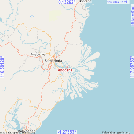
Anggana GPS coordinates[2]
0° 34' 13.8" South, 117° 17' 3.84" East
| Map corner | latitude | longitude |
|---|---|---|
| Upper-left | 0.13262°, | 116.58128° |
| Center: | -0.5705°, | 117.2844° |
| Lower-right: | -1.27353°, | 117.98753° |
| Map W x H: | 156.3×156.4 km | = 97.1×97.2mi |
| max Lat: | 5.88969° ⇑5.5% North |
| Anggana: | -0.5705° |
| min Lat: | ⇓94.5% South -10.934° |
| min Long | Anggana | max Long |
| 95.1345° | 117.2844° | 140.9419° |
| W 78.8%⇐ | ⇒21.2% E |
Elevation
Elevation of Anggana is 3 m = 10 ft, and this is 226.7 m = 744 ft below average elevation for this country.
| Max E: |
3185 m = 10449 ft | 99.4% |
| Avg. | 229.7 m = 754 ft | |
| Anggana | 3 m = 10 ft | |
Min E: |
-1 m = -3 ft | 0.6% |
See also: Indonesia elevation on elevation.city.
Geographical zone
Anggana is located in South Torrid zone (between Equator and Tropic of Capricorn). Distance of Equator is 63.4 km =39.4 mi to North.| Distance of | km | miles | from Anggana |
|---|---|---|---|
| Equator | 63.4 | 39.4 | to North |
| Tropic Capricorn | 2542.5 | 1579.8 | to South |
| Antarctic Circle | 7337.7 | 4559.4 | to South |
| South Pole | 9943.6 | 6178.7 | to South |


Nearby cities:
15 places around Anggana: (largest is in red/bold)
• Balikpapan
92.6 km =57.5 mi,  213°
213°
• Bontang
81.3 km =50.5 mi,  15°
15°
• Bontang Baru
79.9 km =49.6 mi, 16°
• City of Balikpapan
86.4 km =53.7 mi, 210°
• Handilenam
28.5 km =17.7 mi,  187°
187°
• Loa Janan
21.1 km =13.1 mi,  266°
266°
• Loakulu
30.5 km =19 mi,  281°
281°
• Muarabadak
29.6 km =18.4 mi,  34°
34°
• Palaran
9.9 km =6.2 mi, 269°
• Penajam
94.7 km =58.8 mi,  217°
217°
• Samarinda
17.7 km =11 mi,  299°
299°
• Samboja
58.5 km =36.4 mi, 208°
• Sangasangadalam
11.5 km =7.1 mi, 207°
• Sangatta
122.6 km =76.2 mi,  12°
12°
• Sebulu
45.8 km =28.5 mi,  316°
316°
Sources, notices
• [Note1] Compared only with cities in Indonesia existing in our database
• [Src1] Map data: © OpenStreetMap contributors (CC-BY-SA)
• [Src2] Other city data from geonames.org with taken over terms of usage.
• [Src3] Geographical zone / Annual Mean Temperature by Robert A. Rohde @ Wikipedia
