Loakulu geodata
Loakulu (East Kalimantan) is a seat of a third-order administrative division; located in Indonesia in Asia/Makassar (GMT+8) time zone. In our database, there are 407 cities with bigger population. Compared to other cities in Indonesia, 94.6% of cities are located further ↓South; 78.4% of cities are located further ←West and 86.4% of cities have higher elevation than Loakulu. Note1


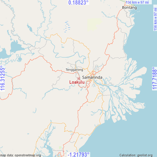
Loakulu GPS coordinates[2]
0° 30' 53.604" South, 117° 0' 56.412" East
| Map corner | latitude | longitude |
|---|---|---|
| Upper-left | 0.18823°, | 116.31255° |
| Center: | -0.51489°, | 117.01567° |
| Lower-right: | -1.21793°, | 117.7188° |
| Map W x H: | 156.4×156.4 km | = 97.2×97.2mi |
| max Lat: | 5.88969° ⇑5.4% North |
| Loakulu: | -0.51489° |
| min Lat: | ⇓94.6% South -10.934° |
| min Long | Loakulu | max Long |
| 95.1345° | 117.01567° | 140.9419° |
| W 78.4%⇐ | ⇒21.6% E |
Elevation
Elevation of Loakulu is 13 m = 43 ft, and this is 216.7 m = 711 ft below average elevation for this country.
| Max E: |
3185 m = 10449 ft | 86.4% |
| Avg. | 229.7 m = 754 ft | |
| Loakulu | 13 m = 43 ft | |
Min E: |
-1 m = -3 ft | 13.6% |
See also: Indonesia elevation on elevation.city.
Geographical zone
Loakulu is located in South Torrid zone (between Equator and Tropic of Capricorn). Distance of Equator is 57.3 km =35.6 mi to North.| Distance of | km | miles | from Loakulu |
|---|---|---|---|
| Equator | 57.3 | 35.6 | to North |
| Tropic Capricorn | 2548.7 | 1583.7 | to South |
| Antarctic Circle | 7343.9 | 4563.3 | to South |
| South Pole | 9949.8 | 6182.5 | to South |


Nearby cities:
15 places around Loakulu: (largest is in red/bold)
• Anggana
30.5 km =19 mi,  101°
101°
• Balikpapan
86.2 km =53.6 mi,  193°
193°
• Bontang
88.9 km =55.2 mi,  35°
35°
• Bontang Baru
87.8 km =54.6 mi, 36°
• City of Balikpapan
82 km =51 mi, 189°
• Handilenam
43.1 km =26.8 mi,  143°
143°
• Loa Janan
11.6 km =7.2 mi,  130°
130°
• Muarabadak
50.1 km =31.1 mi,  68°
68°
• Palaran
21 km =13 mi,  107°
107°
• Penajam
86.1 km =53.5 mi,  198°
198°
• Samarinda
14.7 km =9.1 mi,  79°
79°
• Samboja
57.7 km =35.9 mi,  178°
178°
• Sangasangadalam
29.5 km =18.3 mi,  123°
123°
• Sangatta
126.9 km =78.9 mi,  26°
26°
• Sebulu
26.9 km =16.7 mi,  355°
355°
Sources, notices
• [Note1] Compared only with cities in Indonesia existing in our database
• [Src1] Map data: © OpenStreetMap contributors (CC-BY-SA)
• [Src2] Other city data from geonames.org with taken over terms of usage.
• [Src3] Geographical zone / Annual Mean Temperature by Robert A. Rohde @ Wikipedia
