Pulo Batal geodata
Pulo Batal (Aceh) is a seat of a third-order administrative division; located in Indonesia in Asia/Jakarta (GMT+7) time zone. In our database, there are 407 cities with bigger population. Compared to other cities in Indonesia, 97.4% of cities are located further ↓South; 99% of cities are located further →East and 84.2% of cities have higher elevation than Pulo Batal. Note1


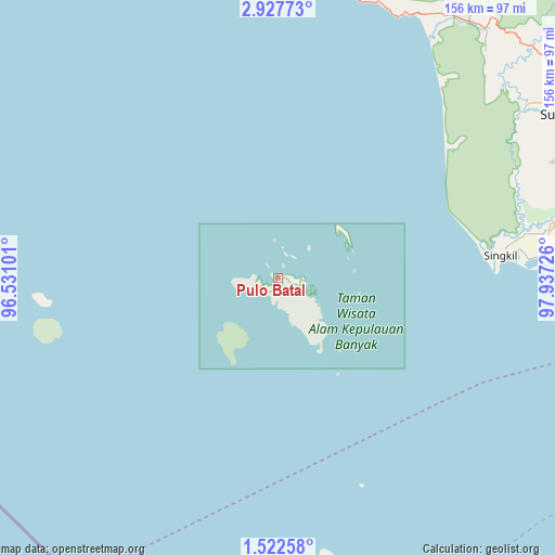
Pulo Batal GPS coordinates[2]
2° 13' 31.152" North, 97° 14' 2.868" East
| Map corner | latitude | longitude |
|---|---|---|
| Upper-left | 2.92773°, | 96.53101° |
| Center: | 2.22532°, | 97.23413° |
| Lower-right: | 1.52258°, | 97.93726° |
| Map W x H: | 156.2×156.2 km | = 97.1×97.1mi |
| max Lat: | 5.88969° ⇑2.6% North |
| Pulo Batal: | 2.22532° |
| min Lat: | ⇓97.4% South -10.934° |
| min Long | Pulo Batal | max Long |
| 95.1345° | 97.23413° | 140.9419° |
| W 1%⇐ | ⇒99% E |
Elevation
Elevation of Pulo Batal is 15 m = 49 ft, and this is 214.7 m = 704 ft below average elevation for this country.
| Max E: |
3185 m = 10449 ft | 84.2% |
| Avg. | 229.7 m = 754 ft | |
| Pulo Batal | 15 m = 49 ft | |
Min E: |
-1 m = -3 ft | 15.8% |
See also: Indonesia elevation on elevation.city.
Geographical zone
Pulo Batal is located in North Torrid zone (between Equator and Tropic of Cancer). Distance of Equator is 247.4 km =153.7 mi to South.| Distance of | km | miles | from Pulo Batal |
|---|---|---|---|
| North Pole | 9759.6 | 6064.3 | to North |
| Arctic Circle | 7153.7 | 4445.1 | to North |
| Tropic Cancer | 2358.5 | 1465.5 | to North |
| Equator | 247.4 | 153.7 | to South |


Nearby cities:
15 places around Pulo Batal: (largest is in red/bold)
• Bakungan
82.5 km =51.3 mi,  19°
19°
• Danauparis
96.8 km =60.1 mi,  77°
77°
• Gosong Telaga
77.2 km =48 mi,  85°
85°
• Jambi Baru
95.3 km =59.2 mi,  49°
49°
• Krueng Luak
91.3 km =56.7 mi,  39°
39°
• Kuala Baru
61.5 km =38.2 mi, 87°
• Kuala Baru Sungai
59.8 km =37.2 mi,  70°
70°
• Labuhan Bajau
88.7 km =55.1 mi,  282°
282°
• Lotu
89.4 km =55.6 mi,  171°
171°
• Pasir Panjang
98.7 km =61.3 mi,  59°
59°
• Pulopaya
85.7 km =53.3 mi,  32°
32°
• Rimo
82.1 km =51 mi, 79°
• Rundeng
84.1 km =52.3 mi, 52°
• Singkil
62 km =38.5 mi, 83°
• Suak Bakung
88 km =54.7 mi,  9°
9°
Sources, notices
• [Note1] Compared only with cities in Indonesia existing in our database
• [Src1] Map data: © OpenStreetMap contributors (CC-BY-SA)
• [Src2] Other city data from geonames.org with taken over terms of usage.
• [Src3] Geographical zone / Annual Mean Temperature by Robert A. Rohde @ Wikipedia
