Angan geodata
Angan (Aceh) is a seat of a third-order administrative division; located in Indonesia in Asia/Jakarta (GMT+7) time zone. In our database, there are 407 cities with bigger population. Compared to other cities in Indonesia, 100% of cities are located further ↓South; 99.9% of cities are located further →East and 99.4% of cities have higher elevation than Angan. Note1


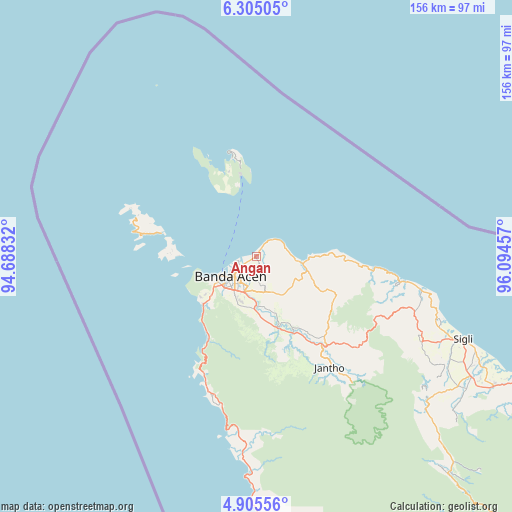
Angan GPS coordinates[2]
5° 36' 20.592" North, 95° 23' 29.184" East
| Map corner | latitude | longitude |
|---|---|---|
| Upper-left | 6.30505°, | 94.68832° |
| Center: | 5.60572°, | 95.39144° |
| Lower-right: | 4.90556°, | 96.09457° |
| Map W x H: | 155.6×155.6 km | = 96.7×96.7mi |
| max Lat: | 5.88969° ⇑0% North |
| Angan: | 5.60572° |
| min Lat: | ⇓100% South -10.934° |
| min Long | Angan | max Long |
| 95.1345° | 95.39144° | 140.9419° |
| W 0.1%⇐ | ⇒99.9% E |
Elevation
Elevation of Angan is 3 m = 10 ft, and this is 226.7 m = 744 ft below average elevation for this country.
| Max E: |
3185 m = 10449 ft | 99.4% |
| Avg. | 229.7 m = 754 ft | |
| Angan | 3 m = 10 ft | |
Min E: |
-1 m = -3 ft | 0.6% |
See also: Indonesia elevation on elevation.city.
Geographical zone
Angan is located in North Torrid zone (between Equator and Tropic of Cancer). Distance of Equator is 623.3 km =387.3 mi to South.| Distance of | km | miles | from Angan |
|---|---|---|---|
| North Pole | 9383.8 | 5830.8 | to North |
| Arctic Circle | 6777.9 | 4211.6 | to North |
| Tropic Cancer | 1982.6 | 1231.9 | to North |
| Equator | 623.3 | 387.3 | to South |


Nearby cities:
15 places around Angan: (largest is in red/bold)
• Banda Aceh
9.6 km =6 mi,  222°
222°
• Indrapuri
14.6 km =9.1 mi,  168°
168°
• Kruengraya
13.7 km =8.5 mi,  97°
97°
• Lambaro
7.7 km =4.8 mi, 223°
• Lampuuk
3.9 km =2.4 mi,  183°
183°
• Lampuyang
29.3 km =18.2 mi,  284°
284°
• Lhoknga
21.6 km =13.4 mi,  228°
228°
• Lhoong
40.8 km =25.4 mi,  202°
202°
• Luthu
32.5 km =20.2 mi, 177°
• Mata Ie
10.7 km =6.6 mi, 215°
• Montasik
12 km =7.5 mi,  163°
163°
• Peukanbada
19.6 km =12.2 mi,  246°
246°
• Sabang
32.6 km =20.3 mi,  345°
345°
• Seulimeum
34 km =21.1 mi,  142°
142°
• Sibreh
9.9 km =6.2 mi,  191°
191°
Sources, notices
• [Note1] Compared only with cities in Indonesia existing in our database
• [Src1] Map data: © OpenStreetMap contributors (CC-BY-SA)
• [Src2] Other city data from geonames.org with taken over terms of usage.
• [Src3] Geographical zone / Annual Mean Temperature by Robert A. Rohde @ Wikipedia
