Banda Aceh geodata
Banda Aceh (Aceh) is a seat of a first-order administrative division; located in Indonesia in Asia/Jakarta (GMT+7) time zone. With population of 250,757 people, there are 40 cities with bigger population in this country. Compared to other cities in Indonesia, 99.9% of cities are located further ↓South; 99.9% of cities are located further →East and 92.1% of cities have higher elevation than Banda Aceh. Note1


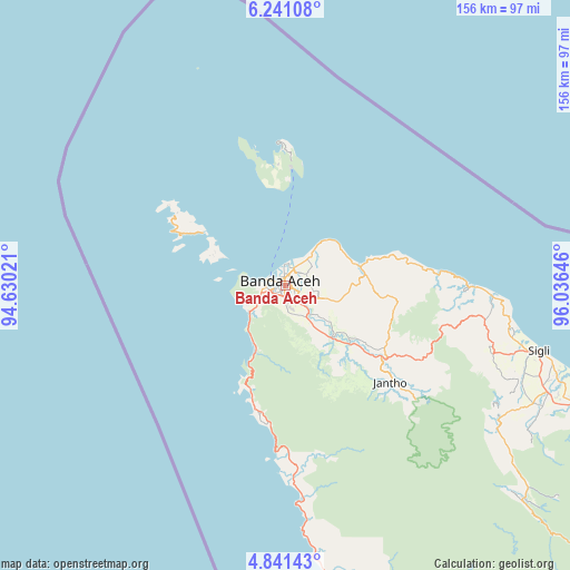
Banda Aceh GPS coordinates[2]
5° 32' 30.012" North, 95° 19' 59.988" East
| Map corner | latitude | longitude |
|---|---|---|
| Upper-left | 6.24108°, | 94.63021° |
| Center: | 5.54167°, | 95.33333° |
| Lower-right: | 4.84143°, | 96.03646° |
| Map W x H: | 155.6×155.6 km | = 96.7×96.7mi |
| max Lat: | 5.88969° ⇑0.1% North |
| Banda Aceh: | 5.54167° |
| min Lat: | ⇓99.9% South -10.934° |
| min Long | Banda Aceh | max Long |
| 95.1345° | 95.33333° | 140.9419° |
| W 0.1%⇐ | ⇒99.9% E |
Elevation
Elevation of Banda Aceh is 9 m = 30 ft, and this is 220.7 m = 724 ft below average elevation for this country.
| Max E: |
3185 m = 10449 ft | 92.1% |
| Avg. | 229.7 m = 754 ft | |
| Banda Aceh | 9 m = 30 ft | |
Min E: |
-1 m = -3 ft | 7.9% |
See also: Banda Aceh elevation on elevation.city.
Geographical zone
Banda Aceh is located in North Torrid zone (between Equator and Tropic of Cancer). Distance of Equator is 616.2 km =382.9 mi to South.| Distance of | km | miles | from Banda Aceh |
|---|---|---|---|
| North Pole | 9390.9 | 5835.2 | to North |
| Arctic Circle | 6785 | 4216 | to North |
| Tropic Cancer | 1989.7 | 1236.3 | to North |
| Equator | 616.2 | 382.9 | to South |


Nearby cities:
15 places around Banda Aceh: (largest is in red/bold)
• Angan
9.6 km =6 mi,  42°
42°
• Indrapuri
11.8 km =7.3 mi,  127°
127°
• Kruengraya
20.7 km =12.9 mi,  75°
75°
• Lambaro
2 km =1.2 mi, 36°
• Lampuuk
7 km =4.3 mi,  62°
62°
• Lampuyang
26.2 km =16.3 mi,  302°
302°
• Lhoknga
12.1 km =7.5 mi,  233°
233°
• Lhoong
31.9 km =19.8 mi,  196°
196°
• Luthu
26.5 km =16.5 mi,  163°
163°
• Mata Ie
1.5 km =0.9 mi,  174°
174°
• Montasik
10.8 km =6.7 mi,  113°
113°
• Peukanbada
11.6 km =7.2 mi,  266°
266°
• Sabang
38.7 km =24 mi,  357°
357°
• Seulimeum
33.5 km =20.8 mi, 126°
• Sibreh
5.1 km =3.2 mi,  120°
120°
Sources, notices
• [Note1] Compared only with cities in Indonesia existing in our database
• [Src1] Map data: © OpenStreetMap contributors (CC-BY-SA)
• [Src2] Other city data from geonames.org with taken over terms of usage.
• [Src3] Geographical zone / Annual Mean Temperature by Robert A. Rohde @ Wikipedia
