Peuleumat geodata
Peuleumat (Aceh) is a seat of a third-order administrative division; located in Indonesia in Asia/Jakarta (GMT+7) time zone. In our database, there are 407 cities with bigger population. Compared to other cities in Indonesia, 98.3% of cities are located further ↓South; 99.1% of cities are located further →East and 63.5% of cities have higher elevation than Peuleumat. Note1


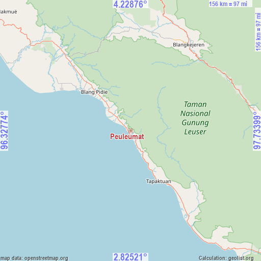
Peuleumat GPS coordinates[2]
3° 31' 38.1" North, 97° 1' 51.096" East
| Map corner | latitude | longitude |
|---|---|---|
| Upper-left | 4.22876°, | 96.32774° |
| Center: | 3.52725°, | 97.03086° |
| Lower-right: | 2.82521°, | 97.73399° |
| Map W x H: | 156.1×156.1 km | = 97×97mi |
| max Lat: | 5.88969° ⇑1.7% North |
| Peuleumat: | 3.52725° |
| min Lat: | ⇓98.3% South -10.934° |
| min Long | Peuleumat | max Long |
| 95.1345° | 97.03086° | 140.9419° |
| W 0.9%⇐ | ⇒99.1% E |
Elevation
Elevation of Peuleumat is 47 m = 154 ft, and this is 182.7 m = 599 ft below average elevation for this country.
| Max E: |
3185 m = 10449 ft | 63.5% |
| Avg. | 229.7 m = 754 ft | |
| Peuleumat | 47 m = 154 ft | |
Min E: |
-1 m = -3 ft | 36.5% |
See also: Indonesia elevation on elevation.city.
Geographical zone
Peuleumat is located in North Torrid zone (between Equator and Tropic of Cancer). Distance of Equator is 392.2 km =243.7 mi to South.| Distance of | km | miles | from Peuleumat |
|---|---|---|---|
| North Pole | 9614.9 | 5974.4 | to North |
| Arctic Circle | 7009 | 4355.2 | to North |
| Tropic Cancer | 2213.7 | 1375.5 | to North |
| Equator | 392.2 | 243.7 | to South |


Nearby cities:
15 places around Peuleumat: (largest is in red/bold)
• Babah Rot
58.6 km =36.4 mi,  319°
319°
• Blangpidie
32 km =19.9 mi, 317°
• Kota Trieng
11 km =6.8 mi, 316°
• Kotabahagia
43.8 km =27.2 mi, 317°
• Mersak
39 km =24.2 mi,  92°
92°
• Meukek
6.7 km =4.2 mi,  148°
148°
• Paya Dapur
55.6 km =34.5 mi,  129°
129°
• Pulo Ie
45.2 km =28.1 mi, 127°
• Samadua
24 km =14.9 mi, 152°
• Sawang
15.8 km =9.8 mi, 150°
• Seupakat
49.6 km =30.8 mi,  74°
74°
• Suek
36.3 km =22.6 mi, 319°
• Susoh
31.9 km =19.8 mi,  313°
313°
• Tangantangancut
23.7 km =14.7 mi, 318°
• Terbangan
43.8 km =27.2 mi,  142°
142°
Sources, notices
• [Note1] Compared only with cities in Indonesia existing in our database
• [Src1] Map data: © OpenStreetMap contributors (CC-BY-SA)
• [Src2] Other city data from geonames.org with taken over terms of usage.
• [Src3] Geographical zone / Annual Mean Temperature by Robert A. Rohde @ Wikipedia
