Kuala Tuha geodata
Kuala Tuha (Aceh) is a seat of a third-order administrative division; located in Indonesia in Asia/Jakarta (GMT+7) time zone. In our database, there are 407 cities with bigger population. Compared to other cities in Indonesia, 98.8% of cities are located further ↓South; 99.5% of cities are located further →East and 95.5% of cities have higher elevation than Kuala Tuha. Note1


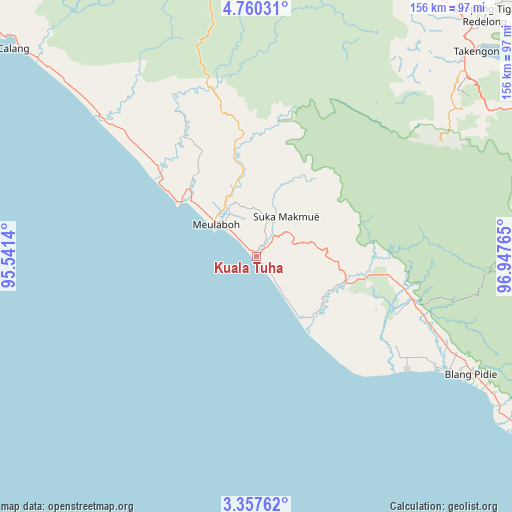
Kuala Tuha GPS coordinates[2]
4° 3' 33.372" North, 96° 14' 40.272" East
| Map corner | latitude | longitude |
|---|---|---|
| Upper-left | 4.76031°, | 95.5414° |
| Center: | 4.05927°, | 96.24452° |
| Lower-right: | 3.35762°, | 96.94765° |
| Map W x H: | 156×156 km | = 96.9×96.9mi |
| max Lat: | 5.88969° ⇑1.2% North |
| Kuala Tuha: | 4.05927° |
| min Lat: | ⇓98.8% South -10.934° |
| min Long | Kuala Tuha | max Long |
| 95.1345° | 96.24452° | 140.9419° |
| W 0.5%⇐ | ⇒99.5% E |
Elevation
Elevation of Kuala Tuha is 7 m = 23 ft, and this is 222.7 m = 731 ft below average elevation for this country.
| Max E: |
3185 m = 10449 ft | 95.5% |
| Avg. | 229.7 m = 754 ft | |
| Kuala Tuha | 7 m = 23 ft | |
Min E: |
-1 m = -3 ft | 4.5% |
See also: Indonesia elevation on elevation.city.
Geographical zone
Kuala Tuha is located in North Torrid zone (between Equator and Tropic of Cancer). Distance of Equator is 451.3 km =280.4 mi to South.| Distance of | km | miles | from Kuala Tuha |
|---|---|---|---|
| North Pole | 9555.7 | 5937.6 | to North |
| Arctic Circle | 6949.8 | 4318.4 | to North |
| Tropic Cancer | 2154.6 | 1338.8 | to North |
| Equator | 451.3 | 280.4 | to South |


Nearby cities:
15 places around Kuala Tuha: (largest is in red/bold)
• Alue Bilie
35.5 km =22.1 mi,  99°
99°
• Babah Rot
51.4 km =31.9 mi,  106°
106°
• Banda Layung
26.1 km =16.2 mi,  321°
321°
• Beutong Ateuh
30.2 km =18.8 mi,  45°
45°
• Blang Ara
28.4 km =17.6 mi,  29°
29°
• Drien Rampak
42.3 km =26.3 mi,  311°
311°
• Jagongjeget
70.9 km =44.1 mi,  59°
59°
• Kajeung
52 km =32.3 mi,  346°
346°
• Keudee Aron
18.7 km =11.6 mi,  337°
337°
• Kotabahagia
63.7 km =39.6 mi, 114°
• Kuala Bhee
42.4 km =26.3 mi,  328°
328°
• Meulaboh
16.1 km =10 mi, 305°
• Meureubo
12.8 km =8 mi, 314°
• Pantai Ceuremen
34.9 km =21.7 mi, 351°
• Suka Makmue
41.9 km =26 mi, 98°
Sources, notices
• [Note1] Compared only with cities in Indonesia existing in our database
• [Src1] Map data: © OpenStreetMap contributors (CC-BY-SA)
• [Src2] Other city data from geonames.org with taken over terms of usage.
• [Src3] Geographical zone / Annual Mean Temperature by Robert A. Rohde @ Wikipedia
