Danaupanggang geodata
Danaupanggang (South Kalimantan) is a seat of a third-order administrative division; located in Indonesia in Asia/Pontianak (GMT+7) time zone. In our database, there are 407 cities with bigger population. Compared to other cities in Indonesia, 92.4% of cities are located further ↓South; 71% of cities are located further ←West and 99.1% of cities have higher elevation than Danaupanggang. Note1


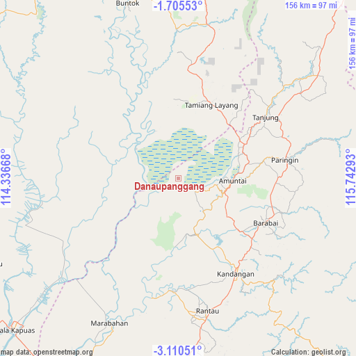
Danaupanggang GPS coordinates[2]
2° 24' 29.52" South, 115° 2' 23.28" East
| Map corner | latitude | longitude |
|---|---|---|
| Upper-left | -1.70553°, | 114.33668° |
| Center: | -2.4082°, | 115.0398° |
| Lower-right: | -3.11051°, | 115.74293° |
| Map W x H: | 156.2×156.2 km | = 97.1×97.1mi |
| max Lat: | 5.88969° ⇑7.6% North |
| Danaupanggang: | -2.4082° |
| min Lat: | ⇓92.4% South -10.934° |
| min Long | Danaupanggang | max Long |
| 95.1345° | 115.0398° | 140.9419° |
| W 71%⇐ | ⇒29% E |
Elevation
Elevation of Danaupanggang is 4 m = 13 ft, and this is 225.7 m = 740 ft below average elevation for this country.
| Max E: |
3185 m = 10449 ft | 99.1% |
| Avg. | 229.7 m = 754 ft | |
| Danaupanggang | 4 m = 13 ft | |
Min E: |
-1 m = -3 ft | 0.9% |
See also: Indonesia elevation on elevation.city.
Geographical zone
Danaupanggang is located in South Torrid zone (between Equator and Tropic of Capricorn). Distance of Equator is 267.8 km =166.4 mi to North.| Distance of | km | miles | from Danaupanggang |
|---|---|---|---|
| Equator | 267.8 | 166.4 | to North |
| Tropic Capricorn | 2338.2 | 1452.9 | to South |
| Antarctic Circle | 7133.4 | 4432.5 | to South |
| South Pole | 9739.3 | 6051.7 | to South |


Nearby cities:
15 places around Danaupanggang: (largest is in red/bold)
• Alabio
23.3 km =14.5 mi,  102°
102°
• Amuntai
23.3 km =14.5 mi,  92°
92°
• Babirik
19.8 km =12.3 mi,  138°
138°
• Barabai
42.8 km =26.6 mi,  117°
117°
• Barikin
43.8 km =27.2 mi,  133°
133°
• Jenamas
15.2 km =9.4 mi,  253°
253°
• Kasarangan
37.5 km =23.3 mi, 130°
• Mengkalip
33.8 km =21 mi,  328°
328°
• Pantaihambawang
41.8 km =26 mi, 129°
• Pasararba
34.9 km =21.7 mi,  61°
61°
• Pasingkan
36.2 km =22.5 mi,  148°
148°
• Pendawanbaru
26.2 km =16.3 mi, 121°
• Sungaiturak
39 km =24.2 mi,  81°
81°
• Tamiang Layang
36.1 km =22.4 mi,  28°
28°
• Telagaselaba
30.6 km =19 mi, 84°
Sources, notices
• [Note1] Compared only with cities in Indonesia existing in our database
• [Src1] Map data: © OpenStreetMap contributors (CC-BY-SA)
• [Src2] Other city data from geonames.org with taken over terms of usage.
• [Src3] Geographical zone / Annual Mean Temperature by Robert A. Rohde @ Wikipedia
