Mengkalip geodata
Mengkalip (Central Kalimantan) is a seat of a third-order administrative division; located in Indonesia in Asia/Pontianak (GMT+7) time zone. In our database, there are 407 cities with bigger population. Compared to other cities in Indonesia, 92.7% of cities are located further ↓South; 70.3% of cities are located further ←West and 95.5% of cities have higher elevation than Mengkalip. Note1


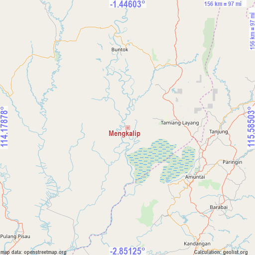
Mengkalip GPS coordinates[2]
2° 8' 55.68" South, 114° 52' 54.84" East
| Map corner | latitude | longitude |
|---|---|---|
| Upper-left | -1.44603°, | 114.17878° |
| Center: | -2.1488°, | 114.8819° |
| Lower-right: | -2.85125°, | 115.58503° |
| Map W x H: | 156.2×156.3 km | = 97.1×97.1mi |
| max Lat: | 5.88969° ⇑7.3% North |
| Mengkalip: | -2.1488° |
| min Lat: | ⇓92.7% South -10.934° |
| min Long | Mengkalip | max Long |
| 95.1345° | 114.8819° | 140.9419° |
| W 70.3%⇐ | ⇒29.7% E |
Elevation
Elevation of Mengkalip is 7 m = 23 ft, and this is 222.7 m = 731 ft below average elevation for this country.
| Max E: |
3185 m = 10449 ft | 95.5% |
| Avg. | 229.7 m = 754 ft | |
| Mengkalip | 7 m = 23 ft | |
Min E: |
-1 m = -3 ft | 4.5% |
See also: Indonesia elevation on elevation.city.
Geographical zone
Mengkalip is located in South Torrid zone (between Equator and Tropic of Capricorn). Distance of Equator is 238.9 km =148.4 mi to North.| Distance of | km | miles | from Mengkalip |
|---|---|---|---|
| Equator | 238.9 | 148.4 | to North |
| Tropic Capricorn | 2367 | 1470.8 | to South |
| Antarctic Circle | 7162.2 | 4450.4 | to South |
| South Pole | 9768.1 | 6069.6 | to South |


Nearby cities:
15 places around Mengkalip: (largest is in red/bold)
• Alabio
52.7 km =32.7 mi,  130°
130°
• Amuntai
50.6 km =31.4 mi, 126°
• Babirik
53.4 km =33.2 mi,  144°
144°
• Buntok
47.8 km =29.7 mi,  354°
354°
• Danaupanggang
33.8 km =21 mi,  148°
148°
• Jenamas
33.2 km =20.6 mi,  174°
174°
• Kelua
57.8 km =35.9 mi,  96°
96°
• Paringin
69.1 km =42.9 mi,  107°
107°
• Pasararba
49.8 km =30.9 mi, 104°
• Pendawanbaru
58.3 km =36.2 mi, 136°
• Sungaiturak
60.5 km =37.6 mi, 112°
• Tamiang Layang
35 km =21.7 mi,  85°
85°
• Tanjung
58.5 km =36.4 mi, 92°
• Tanta
64 km =39.8 mi, 97°
• Telagaselaba
54.6 km =33.9 mi,  118°
118°
Sources, notices
• [Note1] Compared only with cities in Indonesia existing in our database
• [Src1] Map data: © OpenStreetMap contributors (CC-BY-SA)
• [Src2] Other city data from geonames.org with taken over terms of usage.
• [Src3] Geographical zone / Annual Mean Temperature by Robert A. Rohde @ Wikipedia
