Kabare geodata
Kabare (West Papua) is a seat of a third-order administrative division; located in Indonesia in Asia/Jayapura (GMT+9) time zone. In our database, there are 407 cities with bigger population. Compared to other cities in Indonesia, 95.1% of cities are located further ↓South; 98.7% of cities are located further ←West and 52.3% of cities have lower elevation than Kabare. Note1


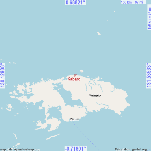
Kabare GPS coordinates[2]
0° 0' 53.64" South, 130° 49' 55.92" East
| Map corner | latitude | longitude |
|---|---|---|
| Upper-left | 0.68821°, | 130.12908° |
| Center: | -0.0149°, | 130.8322° |
| Lower-right: | -0.71801°, | 131.53533° |
| Map W x H: | 156.4×156.4 km | = 97.2×97.2mi |
| max Lat: | 5.88969° ⇑4.9% North |
| Kabare: | -0.0149° |
| min Lat: | ⇓95.1% South -10.934° |
| min Long | Kabare | max Long |
| 95.1345° | 130.8322° | 140.9419° |
| W 98.7%⇐ | ⇒1.3% E |
Elevation
Elevation of Kabare is 111 m = 364 ft, and this is 118.7 m = 389 ft below average elevation for this country.
| Max E: |
3185 m = 10449 ft | 47.7% |
| Avg. | 229.7 m = 754 ft | |
| Kabare | 111 m = 364 ft | |
Min E: |
-1 m = -3 ft | 52.3% |
See also: Indonesia elevation on elevation.city.
Geographical zone
Kabare is located in South Torrid zone (between Equator and Tropic of Capricorn). Distance of Equator is 1.7 km =1.1 mi to North.| Distance of | km | miles | from Kabare |
|---|---|---|---|
| Equator | 1.7 | 1.1 | to North |
| Tropic Capricorn | 2604.3 | 1618.2 | to South |
| Antarctic Circle | 7399.5 | 4597.8 | to South |
| South Pole | 10005.4 | 6217.1 | to South |


Nearby cities:
15 places around Kabare: (largest is in red/bold)
• Aifat
225.5 km =140.1 mi,  124°
124°
• Aimas
118.8 km =73.8 mi,  151°
151°
• Aitinyo
221.5 km =137.6 mi,  130°
130°
• Ayamaru
206.2 km =128.1 mi, 132°
• Doom
106.9 km =66.4 mi,  155°
155°
• Fef
198.6 km =123.4 mi, 116°
• Makbon
113.2 km =70.3 mi,  136°
136°
• Mega
139.4 km =86.6 mi, 121°
• Saonek
47.8 km =29.7 mi,  190°
190°
• Sausapor
149.5 km =92.9 mi,  111°
111°
• Seget
156.1 km =97 mi,  174°
174°
• Sorong
107.3 km =66.7 mi, 153°
• Teminabuan
206 km =128 mi, 140°
• Waisai
43.8 km =27.2 mi,  235°
235°
• Wanurian
159.4 km =99 mi, 149°
Sources, notices
• [Note1] Compared only with cities in Indonesia existing in our database
• [Src1] Map data: © OpenStreetMap contributors (CC-BY-SA)
• [Src2] Other city data from geonames.org with taken over terms of usage.
• [Src3] Geographical zone / Annual Mean Temperature by Robert A. Rohde @ Wikipedia
