Muara geodata
Muara (North Sumatra) is a seat of a third-order administrative division; located in Indonesia in Asia/Jakarta (GMT+7) time zone. In our database, there are 407 cities with bigger population. Compared to other cities in Indonesia, 97.5% of cities are located further ↓South; 97.9% of cities are located further →East and 96.4% of cities have lower elevation than Muara. Note1


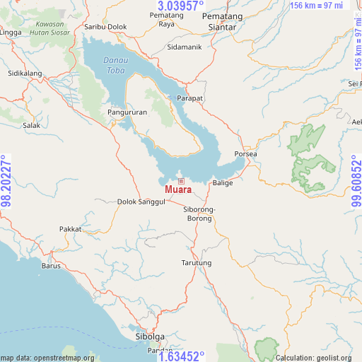
Muara GPS coordinates[2]
2° 20' 13.992" North, 98° 54' 19.404" East
| Map corner | latitude | longitude |
|---|---|---|
| Upper-left | 3.03957°, | 98.20227° |
| Center: | 2.33722°, | 98.90539° |
| Lower-right: | 1.63452°, | 99.60852° |
| Map W x H: | 156.2×156.2 km | = 97.1×97.1mi |
| max Lat: | 5.88969° ⇑2.5% North |
| Muara: | 2.33722° |
| min Lat: | ⇓97.5% South -10.934° |
| min Long | Muara | max Long |
| 95.1345° | 98.90539° | 140.9419° |
| W 2.1%⇐ | ⇒97.9% E |
Elevation
Elevation of Muara is 910 m = 2986 ft, and this is 680.3 m = 2232 ft above average elevation for this country.
| Max E: |
3185 m = 10449 ft | 3.6% |
| Muara | 910 m 2986 ft | |
| Avg. | 229.7 m = 754 ft | |
Min E: |
-1 m = -3 ft | 96.4% |
See also: Indonesia elevation on elevation.city.
Geographical zone
Muara is located in North Torrid zone (between Equator and Tropic of Cancer). Distance of Equator is 259.9 km =161.5 mi to South.| Distance of | km | miles | from Muara |
|---|---|---|---|
| North Pole | 9747.2 | 6056.6 | to North |
| Arctic Circle | 7141.3 | 4437.4 | to North |
| Tropic Cancer | 2346 | 1457.7 | to North |
| Equator | 259.9 | 161.5 | to South |


Nearby cities:
15 places around Muara: (largest is in red/bold)
• Balige
17.8 km =11.1 mi,  91°
91°
• Dolok Sanggul
19.3 km =12 mi,  243°
243°
• Harian
36.3 km =22.6 mi,  312°
312°
• Lintongnihuta
8.1 km =5 mi,  212°
212°
• Mogang
18.5 km =11.5 mi,  322°
322°
• Nainggolan
11.2 km =7 mi,  348°
348°
• Onan Ganjang Satu
36.4 km =22.6 mi, 237°
• Parapat
36.4 km =22.6 mi,  5°
5°
• Parmonangan
30.3 km =18.8 mi, 211°
• Sampuran
37.2 km =23.1 mi,  169°
169°
• Siborong-Borong
15.8 km =9.8 mi,  151°
151°
• Sipoholon
30.6 km =19 mi, 171°
• Tarutung
36.5 km =22.7 mi, 169°
• Tomok Bolon
35.4 km =22 mi, 351°
• Tuktuk Sonak
37.3 km =23.2 mi, 351°
Sources, notices
• [Note1] Compared only with cities in Indonesia existing in our database
• [Src1] Map data: © OpenStreetMap contributors (CC-BY-SA)
• [Src2] Other city data from geonames.org with taken over terms of usage.
• [Src3] Geographical zone / Annual Mean Temperature by Robert A. Rohde @ Wikipedia
