Mogang geodata
Mogang (North Sumatra) is a seat of a third-order administrative division; located in Indonesia in Asia/Jakarta (GMT+7) time zone. In our database, there are 407 cities with bigger population. Compared to other cities in Indonesia, 97.5% of cities are located further ↓South; 98% of cities are located further →East and 96.7% of cities have lower elevation than Mogang. Note1


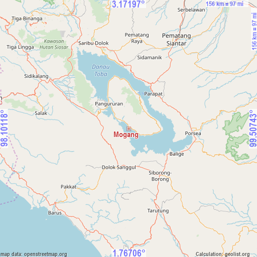
Mogang GPS coordinates[2]
2° 28' 10.92" North, 98° 48' 15.48" East
| Map corner | latitude | longitude |
|---|---|---|
| Upper-left | 3.17197°, | 98.10118° |
| Center: | 2.4697°, | 98.8043° |
| Lower-right: | 1.76706°, | 99.50743° |
| Map W x H: | 156.2×156.2 km | = 97.1×97.1mi |
| max Lat: | 5.88969° ⇑2.5% North |
| Mogang: | 2.4697° |
| min Lat: | ⇓97.5% South -10.934° |
| min Long | Mogang | max Long |
| 95.1345° | 98.8043° | 140.9419° |
| W 2%⇐ | ⇒98% E |
Elevation
Elevation of Mogang is 927 m = 3041 ft, and this is 697.3 m = 2288 ft above average elevation for this country.
| Max E: |
3185 m = 10449 ft | 3.3% |
| Mogang | 927 m 3041 ft | |
| Avg. | 229.7 m = 754 ft | |
Min E: |
-1 m = -3 ft | 96.7% |
See also: Indonesia elevation on elevation.city.
Geographical zone
Mogang is located in North Torrid zone (between Equator and Tropic of Cancer). Distance of Equator is 274.6 km =170.6 mi to South.| Distance of | km | miles | from Mogang |
|---|---|---|---|
| North Pole | 9732.5 | 6047.5 | to North |
| Arctic Circle | 7126.6 | 4428.3 | to North |
| Tropic Cancer | 2331.3 | 1448.6 | to North |
| Equator | 274.6 | 170.6 | to South |


Nearby cities:
15 places around Mogang: (largest is in red/bold)
• Ambarita
23.7 km =14.7 mi,  7°
7°
• Balige
32.8 km =20.4 mi,  117°
117°
• Dolok Sanggul
24.2 km =15 mi,  194°
194°
• Harian
18.4 km =11.4 mi,  301°
301°
• Lintongnihuta
22.6 km =14 mi,  162°
162°
• Muara
18.5 km =11.5 mi,  142°
142°
• Nainggolan
9.7 km =6 mi,  112°
112°
• Onan Ganjang Satu
39.6 km =24.6 mi,  209°
209°
• Pangururan
19.5 km =12.1 mi,  322°
322°
• Parapat
25.9 km =16.1 mi,  34°
34°
• Parmonangan
40.8 km =25.4 mi, 186°
• Siborong-Borong
34.2 km =21.3 mi,  146°
146°
• Sipintuangin
38.2 km =23.7 mi,  357°
357°
• Tomok Bolon
21.2 km =13.2 mi,  17°
17°
• Tuktuk Sonak
22.9 km =14.2 mi, 14°
Sources, notices
• [Note1] Compared only with cities in Indonesia existing in our database
• [Src1] Map data: © OpenStreetMap contributors (CC-BY-SA)
• [Src2] Other city data from geonames.org with taken over terms of usage.
• [Src3] Geographical zone / Annual Mean Temperature by Robert A. Rohde @ Wikipedia
