Pangururan geodata
Pangururan (North Sumatra) is a seat of a second-order administrative division; located in Indonesia in Asia/Jakarta (GMT+7) time zone. In our database, there are 407 cities with bigger population. Compared to other cities in Indonesia, 97.6% of cities are located further ↓South; 98.1% of cities are located further →East and 96.5% of cities have lower elevation than Pangururan. Note1


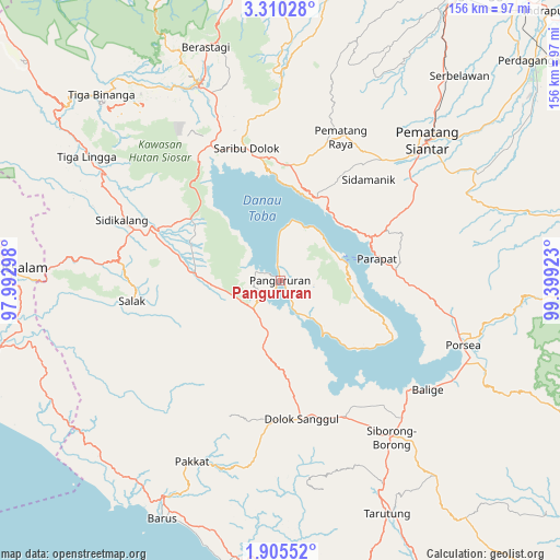
Pangururan GPS coordinates[2]
2° 36' 29.16" North, 98° 41' 45.96" East
| Map corner | latitude | longitude |
|---|---|---|
| Upper-left | 3.31028°, | 97.99298° |
| Center: | 2.6081°, | 98.6961° |
| Lower-right: | 1.90552°, | 99.39923° |
| Map W x H: | 156.2×156.2 km | = 97.1×97.1mi |
| max Lat: | 5.88969° ⇑2.4% North |
| Pangururan: | 2.6081° |
| min Lat: | ⇓97.6% South -10.934° |
| min Long | Pangururan | max Long |
| 95.1345° | 98.6961° | 140.9419° |
| W 1.9%⇐ | ⇒98.1% E |
Elevation
Elevation of Pangururan is 913 m = 2995 ft, and this is 683.3 m = 2242 ft above average elevation for this country.
| Max E: |
3185 m = 10449 ft | 3.5% |
| Pangururan | 913 m 2995 ft | |
| Avg. | 229.7 m = 754 ft | |
Min E: |
-1 m = -3 ft | 96.5% |
See also: Indonesia elevation on elevation.city.
Geographical zone
Pangururan is located in North Torrid zone (between Equator and Tropic of Cancer). Distance of Equator is 290 km =180.2 mi to South.| Distance of | km | miles | from Pangururan |
|---|---|---|---|
| North Pole | 9717.1 | 6037.9 | to North |
| Arctic Circle | 7111.2 | 4418.7 | to North |
| Tropic Cancer | 2315.9 | 1439 | to North |
| Equator | 290 | 180.2 | to South |


Nearby cities:
15 places around Pangururan: (largest is in red/bold)
• Ambarita
17.1 km =10.6 mi,  61°
61°
• Dolok Sanggul
39.3 km =24.4 mi,  171°
171°
• Harian
6.9 km =4.3 mi,  212°
212°
• Mogang
19.5 km =12.1 mi,  142°
142°
• Muara
38 km =23.6 mi, 142°
• Nainggolan
28.4 km =17.6 mi,  132°
132°
• Parapat
27.2 km =16.9 mi,  77°
77°
• Saribudolok
38 km =23.6 mi,  345°
345°
• Sarimatondang
37.5 km =23.3 mi,  40°
40°
• Sipintuangin
25.1 km =15.6 mi,  24°
24°
• Sumbul
36.3 km =22.6 mi,  294°
294°
• Tigarunggu
32.2 km =20 mi,  5°
5°
• Tomok Bolon
18.9 km =11.7 mi, 75°
• Tongging
37.6 km =23.4 mi,  329°
329°
• Tuktuk Sonak
19.2 km =11.9 mi,  69°
69°
Sources, notices
• [Note1] Compared only with cities in Indonesia existing in our database
• [Src1] Map data: © OpenStreetMap contributors (CC-BY-SA)
• [Src2] Other city data from geonames.org with taken over terms of usage.
• [Src3] Geographical zone / Annual Mean Temperature by Robert A. Rohde @ Wikipedia
