Ujungbatu geodata
Ujungbatu (North Sumatra) is a seat of a third-order administrative division; located in Indonesia in Asia/Jakarta (GMT+7) time zone. In our database, there are 407 cities with bigger population. Compared to other cities in Indonesia, 96.3% of cities are located further ↓South; 97.4% of cities are located further →East and 51.6% of cities have lower elevation than Ujungbatu. Note1


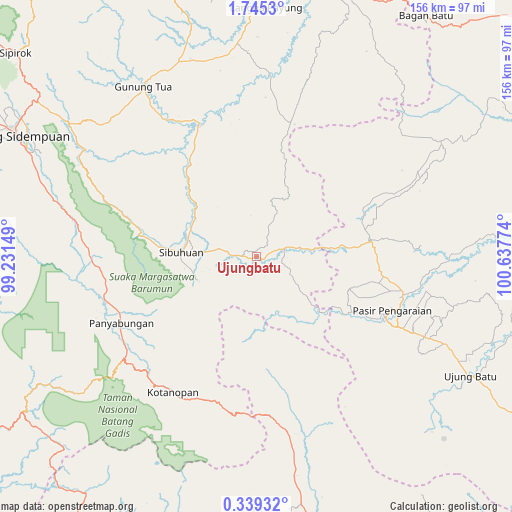
Ujungbatu GPS coordinates[2]
1° 2' 32.604" North, 99° 56' 4.596" East
| Map corner | latitude | longitude |
|---|---|---|
| Upper-left | 1.7453°, | 99.23149° |
| Center: | 1.04239°, | 99.93461° |
| Lower-right: | 0.33932°, | 100.63774° |
| Map W x H: | 156.3×156.3 km | = 97.1×97.1mi |
| max Lat: | 5.88969° ⇑3.7% North |
| Ujungbatu: | 1.04239° |
| min Lat: | ⇓96.3% South -10.934° |
| min Long | Ujungbatu | max Long |
| 95.1345° | 99.93461° | 140.9419° |
| W 2.6%⇐ | ⇒97.4% E |
Elevation
Elevation of Ujungbatu is 108 m = 354 ft, and this is 121.7 m = 399 ft below average elevation for this country.
| Max E: |
3185 m = 10449 ft | 48.4% |
| Avg. | 229.7 m = 754 ft | |
| Ujungbatu | 108 m = 354 ft | |
Min E: |
-1 m = -3 ft | 51.6% |
See also: Indonesia elevation on elevation.city.
Geographical zone
Ujungbatu is located in North Torrid zone (between Equator and Tropic of Cancer). Distance of Equator is 115.9 km =72 mi to South.| Distance of | km | miles | from Ujungbatu |
|---|---|---|---|
| North Pole | 9891.2 | 6146.1 | to North |
| Arctic Circle | 7285.3 | 4526.9 | to North |
| Tropic Cancer | 2490 | 1547.2 | to North |
| Equator | 115.9 | 72 | to South |


Nearby cities:
15 places around Ujungbatu: (largest is in red/bold)
• Binanga
44.5 km =27.7 mi,  336°
336°
• Dalududalu
34.8 km =21.6 mi,  82°
82°
• Gunung Tua
62.5 km =38.8 mi,  326°
326°
• Kotanopan
48.6 km =30.2 mi,  211°
211°
• Kotatengah
69.1 km =42.9 mi,  85°
85°
• Langgapayung
76.2 km =47.3 mi,  2°
2°
• Muara Sipongi
53.3 km =33.1 mi,  170°
170°
• Muara Soma
74.9 km =46.5 mi,  238°
238°
• Panyambungan
46.8 km =29.1 mi,  245°
245°
• Pasarujungbatu
1.7 km =1.1 mi,  115°
115°
• Pasir Pengaraian
44.7 km =27.8 mi, 116°
• Pintupadang
69.1 km =42.9 mi,  288°
288°
• Rokan
74.3 km =46.2 mi,  134°
134°
• Siabu
49 km =30.4 mi,  266°
266°
• Sibuhuan
22.8 km =14.2 mi, 273°
Sources, notices
• [Note1] Compared only with cities in Indonesia existing in our database
• [Src1] Map data: © OpenStreetMap contributors (CC-BY-SA)
• [Src2] Other city data from geonames.org with taken over terms of usage.
• [Src3] Geographical zone / Annual Mean Temperature by Robert A. Rohde @ Wikipedia
