Pasarujungbatu geodata
Pasarujungbatu (North Sumatra) is a seat of a third-order administrative division; located in Indonesia in Asia/Jakarta (GMT+7) time zone. In our database, there are 407 cities with bigger population. Compared to other cities in Indonesia, 96.2% of cities are located further ↓South; 97.4% of cities are located further →East and 50.3% of cities have lower elevation than Pasarujungbatu. Note1


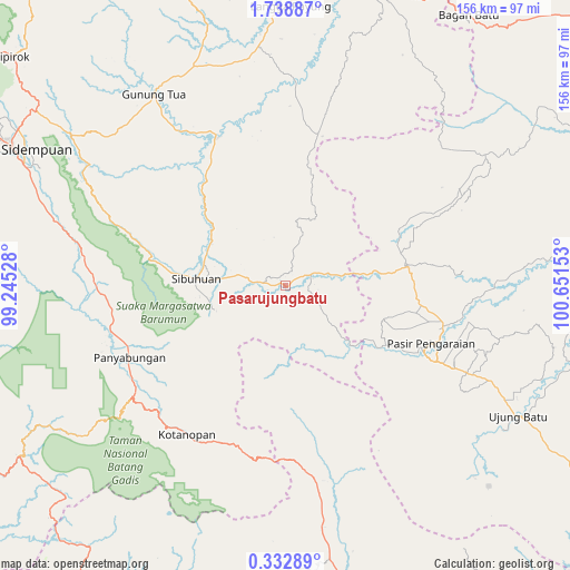
Pasarujungbatu GPS coordinates[2]
1° 2' 9.456" North, 99° 56' 54.24" East
| Map corner | latitude | longitude |
|---|---|---|
| Upper-left | 1.73887°, | 99.24528° |
| Center: | 1.03596°, | 99.9484° |
| Lower-right: | 0.33289°, | 100.65153° |
| Map W x H: | 156.3×156.3 km | = 97.1×97.1mi |
| max Lat: | 5.88969° ⇑3.8% North |
| Pasarujungbatu: | 1.03596° |
| min Lat: | ⇓96.2% South -10.934° |
| min Long | Pasarujungbatu | max Long |
| 95.1345° | 99.9484° | 140.9419° |
| W 2.6%⇐ | ⇒97.4% E |
Elevation
Elevation of Pasarujungbatu is 103 m = 338 ft, and this is 126.7 m = 416 ft below average elevation for this country.
| Max E: |
3185 m = 10449 ft | 49.7% |
| Avg. | 229.7 m = 754 ft | |
| Pasarujungbatu | 103 m = 338 ft | |
Min E: |
-1 m = -3 ft | 50.3% |
See also: Indonesia elevation on elevation.city.
Geographical zone
Pasarujungbatu is located in North Torrid zone (between Equator and Tropic of Cancer). Distance of Equator is 115.2 km =71.6 mi to South.| Distance of | km | miles | from Pasarujungbatu |
|---|---|---|---|
| North Pole | 9891.9 | 6146.5 | to North |
| Arctic Circle | 7286 | 4527.3 | to North |
| Tropic Cancer | 2490.7 | 1547.6 | to North |
| Equator | 115.2 | 71.6 | to South |


Nearby cities:
15 places around Pasarujungbatu: (largest is in red/bold)
• Binanga
45.8 km =28.5 mi,  335°
335°
• Dalududalu
33.3 km =20.7 mi,  81°
81°
• Gunung Tua
64 km =39.8 mi,  325°
325°
• Kotanopan
48.8 km =30.3 mi,  213°
213°
• Kotatengah
67.6 km =42 mi,  85°
85°
• Muara Sipongi
52.4 km =32.6 mi,  172°
172°
• Muara Soma
75.8 km =47.1 mi,  239°
239°
• Panti
75.8 km =47.1 mi, 170°
• Panyambungan
47.9 km =29.8 mi,  246°
246°
• Pasir Pengaraian
43 km =26.7 mi,  116°
116°
• Pintupadang
70.8 km =44 mi,  288°
288°
• Rokan
72.7 km =45.2 mi,  135°
135°
• Siabu
50.5 km =31.4 mi,  267°
267°
• Sibuhuan
24.3 km =15.1 mi, 274°
• Ujungbatu
1.7 km =1.1 mi,  295°
295°
Sources, notices
• [Note1] Compared only with cities in Indonesia existing in our database
• [Src1] Map data: © OpenStreetMap contributors (CC-BY-SA)
• [Src2] Other city data from geonames.org with taken over terms of usage.
• [Src3] Geographical zone / Annual Mean Temperature by Robert A. Rohde @ Wikipedia
