Tobelo geodata
Tobelo (North Maluku) is a populated place; located in Indonesia in Asia/Jayapura (GMT+9) time zone. With population of 10,000 people, there are 376 cities with bigger population in this country. Compared to other cities in Indonesia, 96.9% of cities are located further ↓South; 98.5% of cities are located further ←West and 89% of cities have higher elevation than Tobelo. Note1


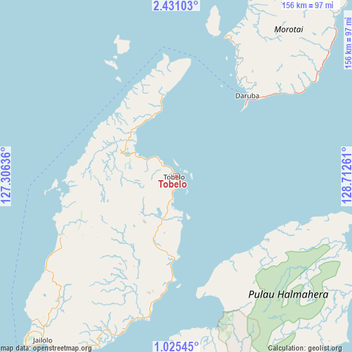
Tobelo GPS coordinates[2]
1° 43' 42.132" North, 128° 0' 34.128" East
| Map corner | latitude | longitude |
|---|---|---|
| Upper-left | 2.43103°, | 127.30636° |
| Center: | 1.72837°, | 128.00948° |
| Lower-right: | 1.02545°, | 128.71261° |
| Map W x H: | 156.3×156.3 km | = 97.1×97.1mi |
| max Lat: | 5.88969° ⇑3.1% North |
| Tobelo: | 1.72837° |
| min Lat: | ⇓96.9% South -10.934° |
| min Long | Tobelo | max Long |
| 95.1345° | 128.00948° | 140.9419° |
| W 98.5%⇐ | ⇒1.5% E |
Elevation
Elevation of Tobelo is 11 m = 36 ft, and this is 218.7 m = 718 ft below average elevation for this country.
| Max E: |
3185 m = 10449 ft | 89% |
| Avg. | 229.7 m = 754 ft | |
| Tobelo | 11 m = 36 ft | |
Min E: |
-1 m = -3 ft | 11% |
See also: Indonesia elevation on elevation.city.
Geographical zone
Tobelo is located in North Torrid zone (between Equator and Tropic of Cancer). Distance of Equator is 192.2 km =119.4 mi to South.| Distance of | km | miles | from Tobelo |
|---|---|---|---|
| North Pole | 9814.9 | 6098.7 | to North |
| Arctic Circle | 7209 | 4479.5 | to North |
| Tropic Cancer | 2413.7 | 1499.8 | to North |
| Equator | 192.2 | 119.4 | to South |


Nearby cities:
15 places around Tobelo: (largest is in red/bold)
• Basiong
127.5 km =79.2 mi,  213°
213°
• Buli
120.1 km =74.6 mi,  164°
164°
• Daruba
47.8 km =29.7 mi,  41°
41°
• Jailolo
95.2 km =59.2 mi,  219°
219°
• Jambula
132.5 km =82.3 mi, 215°
• Kota Ternate
127.1 km =79 mi, 214°
• Maba
118.5 km =73.6 mi, 164°
• Malifud
165.1 km =102.6 mi,  203°
203°
• Petani
171.3 km =106.4 mi, 155°
• Sofifi
121.1 km =75.2 mi, 204°
• Subaim
69 km =42.9 mi,  168°
168°
• Susupu
90.7 km =56.4 mi, 224°
• Ternate
125.3 km =77.9 mi, 213°
• Tongutisungi
56.6 km =35.2 mi,  243°
243°
• Weda
156.3 km =97.1 mi,  185°
185°
Sources, notices
• [Note1] Compared only with cities in Indonesia existing in our database
• [Src1] Map data: © OpenStreetMap contributors (CC-BY-SA)
• [Src2] Other city data from geonames.org with taken over terms of usage.
• [Src3] Geographical zone / Annual Mean Temperature by Robert A. Rohde @ Wikipedia
