Ternate geodata
Ternate (North Maluku) is a populated place; located in Indonesia in Asia/Jayapura (GMT+9) time zone. With population of 101,731 people, there are 129 cities with bigger population in this country. Compared to other cities in Indonesia, 95.9% of cities are located further ↓South; 98.3% of cities are located further ←West and 76.2% of cities have higher elevation than Ternate. Note1


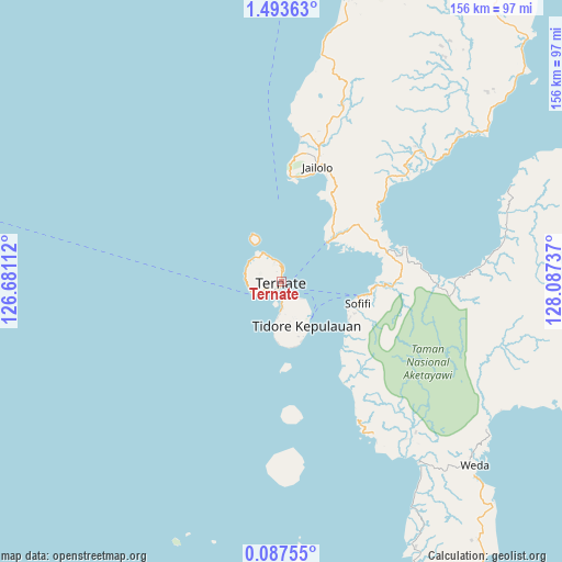
Ternate GPS coordinates[2]
0° 47' 26.34" North, 127° 23' 3.264" East
| Map corner | latitude | longitude |
|---|---|---|
| Upper-left | 1.49363°, | 126.68112° |
| Center: | 0.79065°, | 127.38424° |
| Lower-right: | 0.08755°, | 128.08737° |
| Map W x H: | 156.3×156.3 km | = 97.1×97.1mi |
| max Lat: | 5.88969° ⇑4.1% North |
| Ternate: | 0.79065° |
| min Lat: | ⇓95.9% South -10.934° |
| min Long | Ternate | max Long |
| 95.1345° | 127.38424° | 140.9419° |
| W 98.3%⇐ | ⇒1.7% E |
Elevation
Elevation of Ternate is 23 m = 75 ft, and this is 206.7 m = 678 ft below average elevation for this country.
| Max E: |
3185 m = 10449 ft | 76.2% |
| Avg. | 229.7 m = 754 ft | |
| Ternate | 23 m = 75 ft | |
Min E: |
-1 m = -3 ft | 23.8% |
See also: Ternate elevation on elevation.city.
Geographical zone
Ternate is located in North Torrid zone (between Equator and Tropic of Cancer). Distance of Equator is 87.9 km =54.6 mi to South.| Distance of | km | miles | from Ternate |
|---|---|---|---|
| North Pole | 9919.1 | 6163.4 | to North |
| Arctic Circle | 7313.3 | 4544.3 | to North |
| Tropic Cancer | 2518 | 1564.6 | to North |
| Equator | 87.9 | 54.6 | to South |


Nearby cities:
15 places around Ternate: (largest is in red/bold)
• Basiong
2.2 km =1.4 mi,  207°
207°
• Buli
101.5 km =63.1 mi,  96°
96°
• Guruafin
76.8 km =47.7 mi,  175°
175°
• Jailolo
31.9 km =19.8 mi,  16°
16°
• Jambula
8.2 km =5.1 mi,  243°
243°
• Kota Ternate
2.1 km =1.3 mi,  247°
247°
• Maba
101.4 km =63 mi, 95°
• Mafa
100 km =62.1 mi,  145°
145°
• Malifud
47.7 km =29.6 mi,  174°
174°
• Sofifi
20.3 km =12.6 mi,  106°
106°
• Subaim
91 km =56.5 mi,  66°
66°
• Susupu
40.5 km =25.2 mi,  7°
7°
• Tobelo
125.3 km =77.9 mi,  33°
33°
• Tongutisungi
80.9 km =50.3 mi, 13°
• Weda
74.8 km =46.5 mi,  133°
133°
Sources, notices
• [Note1] Compared only with cities in Indonesia existing in our database
• [Src1] Map data: © OpenStreetMap contributors (CC-BY-SA)
• [Src2] Other city data from geonames.org with taken over terms of usage.
• [Src3] Geographical zone / Annual Mean Temperature by Robert A. Rohde @ Wikipedia
