Maba geodata
Maba (North Maluku) is a seat of a second-order administrative division; located in Indonesia in Asia/Jayapura (GMT+9) time zone. In our database, there are 407 cities with bigger population. Compared to other cities in Indonesia, 95.8% of cities are located further ↓South; 98.5% of cities are located further ←West and 90.6% of cities have higher elevation than Maba. Note1


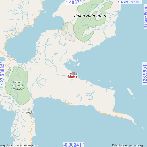
Maba GPS coordinates[2]
0° 42' 2.52" North, 128° 17' 31.092" East
| Map corner | latitude | longitude |
|---|---|---|
| Upper-left | 1.4037°, | 127.58885° |
| Center: | 0.7007°, | 128.29197° |
| Lower-right: | -0.00241°, | 128.9951° |
| Map W x H: | 156.3×156.3 km | = 97.1×97.1mi |
| max Lat: | 5.88969° ⇑4.2% North |
| Maba: | 0.7007° |
| min Lat: | ⇓95.8% South -10.934° |
| min Long | Maba | max Long |
| 95.1345° | 128.29197° | 140.9419° |
| W 98.5%⇐ | ⇒1.5% E |
Elevation
Elevation of Maba is 10 m = 33 ft, and this is 219.7 m = 721 ft below average elevation for this country.
| Max E: |
3185 m = 10449 ft | 90.6% |
| Avg. | 229.7 m = 754 ft | |
| Maba | 10 m = 33 ft | |
Min E: |
-1 m = -3 ft | 9.4% |
See also: Indonesia elevation on elevation.city.
Geographical zone
Maba is located in North Torrid zone (between Equator and Tropic of Cancer). Distance of Equator is 77.9 km =48.4 mi to South.| Distance of | km | miles | from Maba |
|---|---|---|---|
| North Pole | 9929.2 | 6169.7 | to North |
| Arctic Circle | 7323.3 | 4550.5 | to North |
| Tropic Cancer | 2528 | 1570.8 | to North |
| Equator | 77.9 | 48.4 | to South |


Nearby cities:
15 places around Maba: (largest is in red/bold)
• Basiong
102.3 km =63.6 mi,  274°
274°
• Buli
1.7 km =1.1 mi,  183°
183°
• Guruafin
116.4 km =72.3 mi,  235°
235°
• Jailolo
100.2 km =62.3 mi,  293°
293°
• Jambula
108.4 km =67.4 mi, 273°
• Kota Ternate
103.3 km =64.2 mi,  275°
275°
• Mafa
85.3 km =53 mi,  211°
211°
• Malifud
103.6 km =64.4 mi,  248°
248°
• Petani
57.6 km =35.8 mi,  135°
135°
• Sofifi
81.6 km =50.7 mi, 272°
• Subaim
49.9 km =31 mi,  339°
339°
• Susupu
107.9 km =67 mi,  297°
297°
• Ternate
101.4 km =63 mi, 275°
• Tobelo
118.5 km =73.6 mi, 344°
• Weda
62.2 km =38.6 mi,  228°
228°
Sources, notices
• [Note1] Compared only with cities in Indonesia existing in our database
• [Src1] Map data: © OpenStreetMap contributors (CC-BY-SA)
• [Src2] Other city data from geonames.org with taken over terms of usage.
• [Src3] Geographical zone / Annual Mean Temperature by Robert A. Rohde @ Wikipedia
