Sofifi geodata
Sofifi (North Maluku) is a seat of a first-order administrative division; located in Indonesia in Asia/Jayapura (GMT+9) time zone. With population of 36,197 people, there are 284 cities with bigger population in this country. Compared to other cities in Indonesia, 95.8% of cities are located further ↓South; 98.4% of cities are located further ←West and 92.1% of cities have higher elevation than Sofifi. Note1


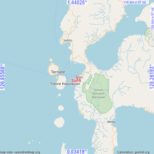
Sofifi GPS coordinates[2]
0° 44' 14.244" North, 127° 33' 31.68" East
| Map corner | latitude | longitude |
|---|---|---|
| Upper-left | 1.44028°, | 126.85568° |
| Center: | 0.73729°, | 127.5588° |
| Lower-right: | 0.03419°, | 128.26193° |
| Map W x H: | 156.3×156.3 km | = 97.1×97.1mi |
| max Lat: | 5.88969° ⇑4.2% North |
| Sofifi: | 0.73729° |
| min Lat: | ⇓95.8% South -10.934° |
| min Long | Sofifi | max Long |
| 95.1345° | 127.5588° | 140.9419° |
| W 98.4%⇐ | ⇒1.6% E |
Elevation
Elevation of Sofifi is 9 m = 30 ft, and this is 220.7 m = 724 ft below average elevation for this country.
| Max E: |
3185 m = 10449 ft | 92.1% |
| Avg. | 229.7 m = 754 ft | |
| Sofifi | 9 m = 30 ft | |
Min E: |
-1 m = -3 ft | 7.9% |
See also: Indonesia elevation on elevation.city.
Geographical zone
Sofifi is located in North Torrid zone (between Equator and Tropic of Cancer). Distance of Equator is 82 km =51 mi to South.| Distance of | km | miles | from Sofifi |
|---|---|---|---|
| North Pole | 9925.1 | 6167.2 | to North |
| Arctic Circle | 7319.2 | 4547.9 | to North |
| Tropic Cancer | 2523.9 | 1568.3 | to North |
| Equator | 82 | 51 | to South |


Nearby cities:
15 places around Sofifi: (largest is in red/bold)
• Basiong
20.8 km =12.9 mi,  280°
280°
• Buli
81.6 km =50.7 mi,  94°
94°
• Guruafin
72 km =44.7 mi,  191°
191°
• Jailolo
37.8 km =23.5 mi,  344°
344°
• Jambula
26.8 km =16.7 mi,  274°
274°
• Kota Ternate
22 km =13.7 mi, 283°
• Maba
81.6 km =50.7 mi, 92°
• Mafa
85.1 km =52.9 mi,  154°
154°
• Malifud
44.2 km =27.5 mi,  200°
200°
• Subaim
76.7 km =47.7 mi,  56°
56°
• Susupu
48.1 km =29.9 mi, 343°
• Ternate
20.3 km =12.6 mi,  286°
286°
• Tobelo
121.1 km =75.2 mi,  24°
24°
• Tongutisungi
84.6 km =52.6 mi,  359°
359°
• Weda
57.3 km =35.6 mi,  142°
142°
Sources, notices
• [Note1] Compared only with cities in Indonesia existing in our database
• [Src1] Map data: © OpenStreetMap contributors (CC-BY-SA)
• [Src2] Other city data from geonames.org with taken over terms of usage.
• [Src3] Geographical zone / Annual Mean Temperature by Robert A. Rohde @ Wikipedia
