Rantaupanjang geodata
Rantaupanjang (Jambi) is a seat of a third-order administrative division; located in Indonesia in Asia/Jakarta (GMT+7) time zone. In our database, there are 407 cities with bigger population. Compared to other cities in Indonesia, 93.1% of cities are located further ↓South; 96% of cities are located further →East and 57.4% of cities have higher elevation than Rantaupanjang. Note1


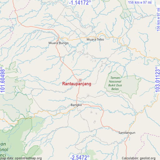
Rantaupanjang GPS coordinates[2]
1° 50' 40.56" South, 102° 18' 29.16" East
| Map corner | latitude | longitude |
|---|---|---|
| Upper-left | -1.14172°, | 101.60498° |
| Center: | -1.8446°, | 102.3081° |
| Lower-right: | -2.5472°, | 103.01123° |
| Map W x H: | 156.3×156.3 km | = 97.1×97.1mi |
| max Lat: | 5.88969° ⇑6.9% North |
| Rantaupanjang: | -1.8446° |
| min Lat: | ⇓93.1% South -10.934° |
| min Long | Rantaupanjang | max Long |
| 95.1345° | 102.3081° | 140.9419° |
| W 4%⇐ | ⇒96% E |
Elevation
Elevation of Rantaupanjang is 70 m = 230 ft, and this is 159.7 m = 524 ft below average elevation for this country.
| Max E: |
3185 m = 10449 ft | 57.4% |
| Avg. | 229.7 m = 754 ft | |
| Rantaupanjang | 70 m = 230 ft | |
Min E: |
-1 m = -3 ft | 42.6% |
See also: Indonesia elevation on elevation.city.
Geographical zone
Rantaupanjang is located in South Torrid zone (between Equator and Tropic of Capricorn). Distance of Equator is 205.1 km =127.4 mi to North.| Distance of | km | miles | from Rantaupanjang |
|---|---|---|---|
| Equator | 205.1 | 127.4 | to North |
| Tropic Capricorn | 2400.8 | 1491.8 | to South |
| Antarctic Circle | 7196.1 | 4471.4 | to South |
| South Pole | 9802 | 6090.7 | to South |


Nearby cities:
15 places around Rantaupanjang: (largest is in red/bold)
• Bangko
26.7 km =16.6 mi,  192°
192°
• Jangkat
78.9 km =49 mi,  200°
200°
• Mersam
78.3 km =48.7 mi,  78°
78°
• Muara Bungo
44.9 km =27.9 mi,  331°
331°
• Muara Tebo
43.7 km =27.2 mi,  20°
20°
• Muara Tembesi
91.3 km =56.7 mi, 80°
• Muaralimun
71.6 km =44.5 mi,  149°
149°
• Muarasiau
53 km =32.9 mi,  205°
205°
• Pauh
65.5 km =40.7 mi,  119°
119°
• Pulautemiang
69.3 km =43.1 mi,  353°
353°
• Rantauambacang
65.8 km =40.9 mi,  319°
319°
• Rantaupangiang
72.7 km =45.2 mi, 185°
• Sarolangun
69.8 km =43.4 mi,  138°
138°
• Sungaibengkal
57.3 km =35.6 mi,  53°
53°
• Surulangun Rawas
100.2 km =62.3 mi, 149°
Sources, notices
• [Note1] Compared only with cities in Indonesia existing in our database
• [Src1] Map data: © OpenStreetMap contributors (CC-BY-SA)
• [Src2] Other city data from geonames.org with taken over terms of usage.
• [Src3] Geographical zone / Annual Mean Temperature by Robert A. Rohde @ Wikipedia
