Muntilan geodata
Muntilan (Central Java) is a populated place; located in Indonesia in Asia/Jakarta (GMT+7) time zone. With population of 44,859 people, there are 251 cities with bigger population in this country. Compared to other cities in Indonesia, 57.7% of cities are located further ↑North; 65.6% of cities are located further →East and 76.3% of cities have lower elevation than Muntilan. Note1


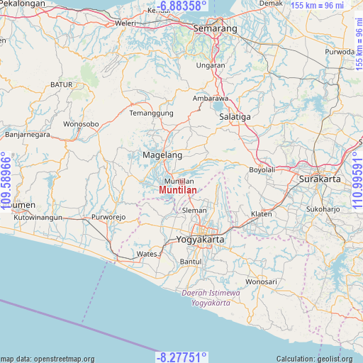
Muntilan GPS coordinates[2]
7° 34' 51.996" South, 110° 17' 34.008" East
| Map corner | latitude | longitude |
|---|---|---|
| Upper-left | -6.88358°, | 109.58966° |
| Center: | -7.58111°, | 110.29278° |
| Lower-right: | -8.27751°, | 110.99591° |
| Map W x H: | 155×155 km | = 96.3×96.3mi |
| max Lat: | 5.88969° ⇑57.7% North |
| Muntilan: | -7.58111° |
| min Lat: | ⇓42.3% South -10.934° |
| min Long | Muntilan | max Long |
| 95.1345° | 110.29278° | 140.9419° |
| W 34.4%⇐ | ⇒65.6% E |
Elevation
Elevation of Muntilan is 377 m = 1237 ft, and this is 147.3 m = 483 ft above average elevation for this country.
| Max E: |
3185 m = 10449 ft | 23.7% |
| Muntilan | 377 m 1237 ft | |
| Avg. | 229.7 m = 754 ft | |
Min E: |
-1 m = -3 ft | 76.3% |
See also: Muntilan elevation on elevation.city.
Geographical zone
Muntilan is located in South Torrid zone (between Equator and Tropic of Capricorn). Distance of Equator is 842.9 km =523.8 mi to North.| Distance of | km | miles | from Muntilan |
|---|---|---|---|
| Equator | 842.9 | 523.8 | to North |
| Tropic Capricorn | 1763 | 1095.5 | to South |
| Antarctic Circle | 6558.2 | 4075.1 | to South |
| South Pole | 9164.1 | 5694.3 | to South |


Nearby cities:
15 places around Muntilan: (largest is in red/bold)
• Candi Prambanan
29.1 km =18.1 mi,  130°
130°
• Depok
25.3 km =15.7 mi,  142°
142°
• Gamping Lor
24.1 km =15 mi,  171°
171°
• Godean
21 km =13 mi,  179°
179°
• Gunung Kendil
30.3 km =18.8 mi,  23°
23°
• Jogonalan
30.1 km =18.7 mi,  116°
116°
• Kasihan
27.6 km =17.1 mi, 171°
• Magelang
14.8 km =9.2 mi,  326°
326°
• Melati
18.8 km =11.7 mi,  154°
154°
• Mertoyudan
10 km =6.2 mi,  312°
312°
• Mungkid
8.2 km =5.1 mi,  261°
261°
• Pugeran Maguwoharjo
25.1 km =15.6 mi, 145°
• Sleman
16.5 km =10.3 mi,  155°
155°
• Temanggung
31.1 km =19.3 mi,  339°
339°
• Yogyakarta
25.7 km =16 mi, 162°
Sources, notices
• [Note1] Compared only with cities in Indonesia existing in our database
• [Src1] Map data: © OpenStreetMap contributors (CC-BY-SA)
• [Src2] Other city data from geonames.org with taken over terms of usage.
• [Src3] Geographical zone / Annual Mean Temperature by Robert A. Rohde @ Wikipedia
