Waghete geodata
Waghete (Papua) is a seat of a third-order administrative division; located in Indonesia in Asia/Jayapura (GMT+9) time zone. In our database, there are 407 cities with bigger population. Compared to other cities in Indonesia, 89.4% of cities are located further ↓South; 99.4% of cities are located further ←West and 99.8% of cities have lower elevation than Waghete. Note1


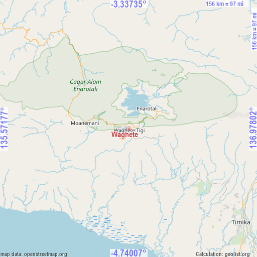
Waghete GPS coordinates[2]
4° 2' 20.436" South, 136° 16' 29.604" East
| Map corner | latitude | longitude |
|---|---|---|
| Upper-left | -3.33735°, | 135.57177° |
| Center: | -4.03901°, | 136.27489° |
| Lower-right: | -4.74007°, | 136.97802° |
| Map W x H: | 156×156 km | = 96.9×96.9mi |
| max Lat: | 5.88969° ⇑10.6% North |
| Waghete: | -4.03901° |
| min Lat: | ⇓89.4% South -10.934° |
| min Long | Waghete | max Long |
| 95.1345° | 136.27489° | 140.9419° |
| W 99.4%⇐ | ⇒0.59999999999999% E |
Elevation
Elevation of Waghete is 1709 m = 5607 ft, and this is 1479.3 m = 4853 ft above average elevation for this country.
| Max E: |
3185 m = 10449 ft | 0.2% |
| Waghete | 1709 m 5607 ft | |
| Avg. | 229.7 m = 754 ft | |
Min E: |
-1 m = -3 ft | 99.8% |
See also: Indonesia elevation on elevation.city.
Geographical zone
Waghete is located in South Torrid zone (between Equator and Tropic of Capricorn). Distance of Equator is 449.1 km =279.1 mi to North.| Distance of | km | miles | from Waghete |
|---|---|---|---|
| Equator | 449.1 | 279.1 | to North |
| Tropic Capricorn | 2156.8 | 1340.2 | to South |
| Antarctic Circle | 6952.1 | 4319.8 | to South |
| South Pole | 9558 | 5939.1 | to South |


Nearby cities:
15 places around Waghete: (largest is in red/bold)
• Beoga
101.4 km =63 mi,  77°
77°
• Bilogai
56.4 km =35 mi,  50°
50°
• Bomomani
50.7 km =31.5 mi,  266°
266°
• Enarotali
16.5 km =10.3 mi,  43°
43°
• Homeyo
47 km =29.2 mi,  27°
27°
• Kigamani
37.7 km =23.4 mi,  283°
283°
• Kumopa
35.5 km =22.1 mi, 47°
• Mapurujaya
93.7 km =58.2 mi,  138°
138°
• Moanemani
19.8 km =12.3 mi,  293°
293°
• Nabire
114.4 km =71.1 mi,  311°
311°
• Obano
13.7 km =8.5 mi,  336°
336°
• Sugapa
92.1 km =57.2 mi,  69°
69°
• Tigi
8.1 km =5 mi,  353°
353°
• Topo
98.8 km =61.4 mi,  304°
304°
• Uta
63.1 km =39.2 mi,  205°
205°
Sources, notices
• [Note1] Compared only with cities in Indonesia existing in our database
• [Src1] Map data: © OpenStreetMap contributors (CC-BY-SA)
• [Src2] Other city data from geonames.org with taken over terms of usage.
• [Src3] Geographical zone / Annual Mean Temperature by Robert A. Rohde @ Wikipedia
