Kwantisore geodata
Kwantisore (Papua) is a seat of a third-order administrative division; located in Indonesia in Asia/Jayapura (GMT+9) time zone. In our database, there are 407 cities with bigger population. Compared to other cities in Indonesia, 90.8% of cities are located further ↓South; 99.2% of cities are located further ←West and 80.9% of cities have higher elevation than Kwantisore. Note1


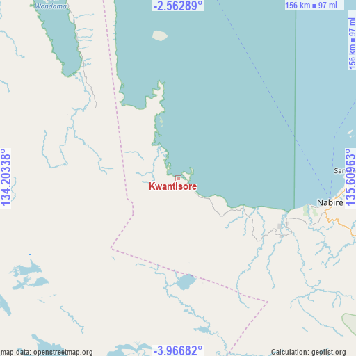
Kwantisore GPS coordinates[2]
3° 15' 54.36" South, 134° 54' 23.4" East
| Map corner | latitude | longitude |
|---|---|---|
| Upper-left | -2.56289°, | 134.20338° |
| Center: | -3.2651°, | 134.9065° |
| Lower-right: | -3.96682°, | 135.60963° |
| Map W x H: | 156.1×156.1 km | = 97×97mi |
| max Lat: | 5.88969° ⇑9.2% North |
| Kwantisore: | -3.2651° |
| min Lat: | ⇓90.8% South -10.934° |
| min Long | Kwantisore | max Long |
| 95.1345° | 134.9065° | 140.9419° |
| W 99.2%⇐ | ⇒0.8% E |
Elevation
Elevation of Kwantisore is 18 m = 59 ft, and this is 211.7 m = 695 ft below average elevation for this country.
| Max E: |
3185 m = 10449 ft | 80.9% |
| Avg. | 229.7 m = 754 ft | |
| Kwantisore | 18 m = 59 ft | |
Min E: |
-1 m = -3 ft | 19.1% |
See also: Indonesia elevation on elevation.city.
Geographical zone
Kwantisore is located in South Torrid zone (between Equator and Tropic of Capricorn). Distance of Equator is 363 km =225.6 mi to North.| Distance of | km | miles | from Kwantisore |
|---|---|---|---|
| Equator | 363 | 225.6 | to North |
| Tropic Capricorn | 2242.9 | 1393.7 | to South |
| Antarctic Circle | 7038.1 | 4373.3 | to South |
| South Pole | 9644 | 5992.5 | to South |


Nearby cities:
15 places around Kwantisore: (largest is in red/bold)
• Bofuer
130.1 km =80.8 mi,  282°
282°
• Bomomani
134.8 km =83.8 mi,  131°
131°
• Enarotali
179.1 km =111.3 mi,  114°
114°
• Homeyo
179 km =111.2 mi,  104°
104°
• Kaimana
134.2 km =83.4 mi,  250°
250°
• Kigamani
138.7 km =86.2 mi,  123°
123°
• Kiruru
75.2 km =46.7 mi,  174°
174°
• Moanemani
154.9 km =96.3 mi, 120°
• Nabire
66.8 km =41.5 mi, 99°
• Obano
163.8 km =101.8 mi, 116°
• Rasiei
65.1 km =40.5 mi,  319°
319°
• Tigi
169.9 km =105.6 mi, 117°
• Topo
76.4 km =47.5 mi, 113°
• Waghete
174.5 km =108.4 mi, 119°
• Wasior
83.4 km =51.8 mi,  326°
326°
Sources, notices
• [Note1] Compared only with cities in Indonesia existing in our database
• [Src1] Map data: © OpenStreetMap contributors (CC-BY-SA)
• [Src2] Other city data from geonames.org with taken over terms of usage.
• [Src3] Geographical zone / Annual Mean Temperature by Robert A. Rohde @ Wikipedia
