Muarauya geodata
Muarauya (South Kalimantan) is a seat of a third-order administrative division; located in Indonesia in Asia/Makassar (GMT+8) time zone. In our database, there are 407 cities with bigger population. Compared to other cities in Indonesia, 93% of cities are located further ↓South; 75.5% of cities are located further ←West and 62.1% of cities have higher elevation than Muarauya. Note1


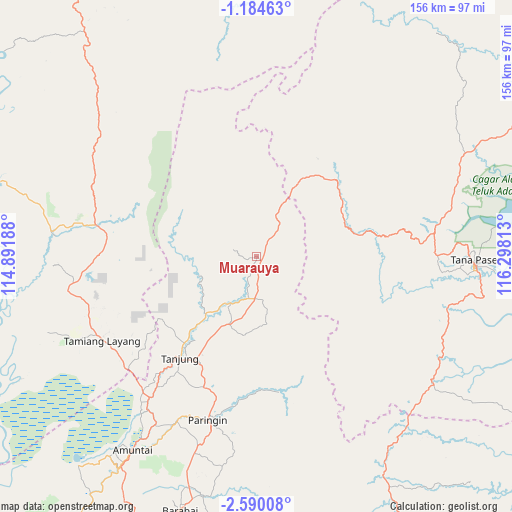
Muarauya GPS coordinates[2]
1° 53' 15" South, 115° 35' 42" East
| Map corner | latitude | longitude |
|---|---|---|
| Upper-left | -1.18463°, | 114.89188° |
| Center: | -1.8875°, | 115.595° |
| Lower-right: | -2.59008°, | 116.29813° |
| Map W x H: | 156.3×156.3 km | = 97.1×97.1mi |
| max Lat: | 5.88969° ⇑7% North |
| Muarauya: | -1.8875° |
| min Lat: | ⇓93% South -10.934° |
| min Long | Muarauya | max Long |
| 95.1345° | 115.595° | 140.9419° |
| W 75.5%⇐ | ⇒24.5% E |
Elevation
Elevation of Muarauya is 51 m = 167 ft, and this is 178.7 m = 586 ft below average elevation for this country.
| Max E: |
3185 m = 10449 ft | 62.1% |
| Avg. | 229.7 m = 754 ft | |
| Muarauya | 51 m = 167 ft | |
Min E: |
-1 m = -3 ft | 37.9% |
See also: Indonesia elevation on elevation.city.
Geographical zone
Muarauya is located in South Torrid zone (between Equator and Tropic of Capricorn). Distance of Equator is 209.9 km =130.4 mi to North.| Distance of | km | miles | from Muarauya |
|---|---|---|---|
| Equator | 209.9 | 130.4 | to North |
| Tropic Capricorn | 2396 | 1488.8 | to South |
| Antarctic Circle | 7191.3 | 4468.5 | to South |
| South Pole | 9797.2 | 6087.7 | to South |


Nearby cities:
15 places around Muarauya: (largest is in red/bold)
• Batusopang
36 km =22.4 mi,  78°
78°
• Halong
41.7 km =25.9 mi,  171°
171°
• Haruai
17.2 km =10.7 mi,  214°
214°
• Juai
46.5 km =28.9 mi,  184°
184°
• Kelua
41.4 km =25.7 mi, 211°
• Kuaro
54.4 km =33.8 mi, 82°
• Lampihung
55.4 km =34.4 mi,  187°
187°
• Muarakomam
33.6 km =20.9 mi,  46°
46°
• Mungkuruyam
42.2 km =26.2 mi, 182°
• Paringin
51.6 km =32.1 mi, 194°
• Pasararba
51.6 km =32.1 mi,  216°
216°
• Sungaiturak
56.8 km =35.3 mi,  204°
204°
• Tamiang Layang
51.5 km =32 mi,  239°
239°
• Tanjung
37.8 km =23.5 mi, 213°
• Tanta
41.1 km =25.5 mi, 202°
Sources, notices
• [Note1] Compared only with cities in Indonesia existing in our database
• [Src1] Map data: © OpenStreetMap contributors (CC-BY-SA)
• [Src2] Other city data from geonames.org with taken over terms of usage.
• [Src3] Geographical zone / Annual Mean Temperature by Robert A. Rohde @ Wikipedia
