Muarakuang geodata
Muarakuang (South Sumatra) is a seat of a third-order administrative division; located in Indonesia in Asia/Jakarta (GMT+7) time zone. In our database, there are 407 cities with bigger population. Compared to other cities in Indonesia, 90% of cities are located further ↓South; 94.8% of cities are located further →East and 78.1% of cities have higher elevation than Muarakuang. Note1


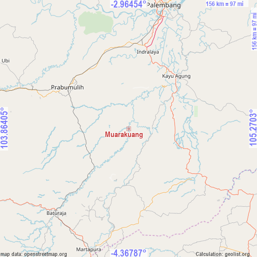
Muarakuang GPS coordinates[2]
3° 39' 59.328" South, 104° 34' 1.812" East
| Map corner | latitude | longitude |
|---|---|---|
| Upper-left | -2.96454°, | 103.86405° |
| Center: | -3.66648°, | 104.56717° |
| Lower-right: | -4.36787°, | 105.2703° |
| Map W x H: | 156×156 km | = 96.9×96.9mi |
| max Lat: | 5.88969° ⇑10% North |
| Muarakuang: | -3.66648° |
| min Lat: | ⇓90% South -10.934° |
| min Long | Muarakuang | max Long |
| 95.1345° | 104.56717° | 140.9419° |
| W 5.2%⇐ | ⇒94.8% E |
Elevation
Elevation of Muarakuang is 21 m = 69 ft, and this is 208.7 m = 685 ft below average elevation for this country.
| Max E: |
3185 m = 10449 ft | 78.1% |
| Avg. | 229.7 m = 754 ft | |
| Muarakuang | 21 m = 69 ft | |
Min E: |
-1 m = -3 ft | 21.9% |
See also: Indonesia elevation on elevation.city.
Geographical zone
Muarakuang is located in South Torrid zone (between Equator and Tropic of Capricorn). Distance of Equator is 407.7 km =253.3 mi to North.| Distance of | km | miles | from Muarakuang |
|---|---|---|---|
| Equator | 407.7 | 253.3 | to North |
| Tropic Capricorn | 2198.2 | 1365.9 | to South |
| Antarctic Circle | 6993.5 | 4345.6 | to South |
| South Pole | 9599.4 | 5964.8 | to South |


Nearby cities:
15 places around Muarakuang: (largest is in red/bold)
• Baturaja
67.9 km =42.2 mi,  220°
220°
• Cempaka
13.3 km =8.3 mi,  123°
123°
• Glumbang
49.6 km =30.8 mi,  343°
343°
• Indralaya
47.6 km =29.6 mi,  14°
14°
• Kayu Agung
42.3 km =26.3 mi,  43°
43°
• Kurungannyawa
64.6 km =40.1 mi,  190°
190°
• Martapura
76.5 km =47.5 mi,  198°
198°
• Pedamaran
36 km =22.4 mi,  56°
56°
• Peninjawan
30.5 km =19 mi, 222°
• Prabumulih
45.4 km =28.2 mi,  304°
304°
• Suban Jeriji
67.5 km =41.9 mi,  262°
262°
• Sungairotan
70.4 km =43.7 mi,  332°
332°
• Tanjung Lubuk
26.3 km =16.3 mi,  53°
53°
• Tanjung Lubuk
45.8 km =28.5 mi, 41°
• Tanjungraja
43.2 km =26.8 mi,  32°
32°
Sources, notices
• [Note1] Compared only with cities in Indonesia existing in our database
• [Src1] Map data: © OpenStreetMap contributors (CC-BY-SA)
• [Src2] Other city data from geonames.org with taken over terms of usage.
• [Src3] Geographical zone / Annual Mean Temperature by Robert A. Rohde @ Wikipedia
