Sungairotan geodata
Sungairotan (South Sumatra) is a seat of a third-order administrative division; located in Indonesia in Asia/Jakarta (GMT+7) time zone. In our database, there are 407 cities with bigger population. Compared to other cities in Indonesia, 91% of cities are located further ↓South; 95% of cities are located further →East and 86.4% of cities have higher elevation than Sungairotan. Note1


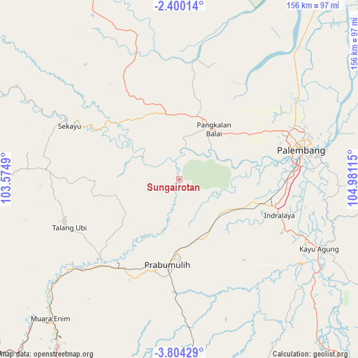
Sungairotan GPS coordinates[2]
3° 6' 8.82" South, 104° 16' 40.872" East
| Map corner | latitude | longitude |
|---|---|---|
| Upper-left | -2.40014°, | 103.5749° |
| Center: | -3.10245°, | 104.27802° |
| Lower-right: | -3.80429°, | 104.98115° |
| Map W x H: | 156.1×156.1 km | = 97×97mi |
| max Lat: | 5.88969° ⇑9% North |
| Sungairotan: | -3.10245° |
| min Lat: | ⇓91% South -10.934° |
| min Long | Sungairotan | max Long |
| 95.1345° | 104.27802° | 140.9419° |
| W 5%⇐ | ⇒95% E |
Elevation
Elevation of Sungairotan is 13 m = 43 ft, and this is 216.7 m = 711 ft below average elevation for this country.
| Max E: |
3185 m = 10449 ft | 86.4% |
| Avg. | 229.7 m = 754 ft | |
| Sungairotan | 13 m = 43 ft | |
Min E: |
-1 m = -3 ft | 13.6% |
See also: Indonesia elevation on elevation.city.
Geographical zone
Sungairotan is located in South Torrid zone (between Equator and Tropic of Capricorn). Distance of Equator is 345 km =214.4 mi to North.| Distance of | km | miles | from Sungairotan |
|---|---|---|---|
| Equator | 345 | 214.4 | to North |
| Tropic Capricorn | 2261 | 1404.9 | to South |
| Antarctic Circle | 7056.2 | 4384.5 | to South |
| South Pole | 9662.1 | 6003.7 | to South |


Nearby cities:
15 places around Sungairotan: (largest is in red/bold)
• Glumbang
23.3 km =14.5 mi,  130°
130°
• Gunungmegang Dalam
59.5 km =37 mi,  229°
229°
• Gunungmenang
28.5 km =17.7 mi,  252°
252°
• Indralaya
47.2 km =29.3 mi,  110°
110°
• Kayu Agung
69.3 km =43.1 mi,  117°
117°
• Muarakuang
70.4 km =43.7 mi,  152°
152°
• Palembang
55.9 km =34.7 mi,  68°
68°
• Pangkalan Balai
27.8 km =17.3 mi,  27°
27°
• Prabumulih
37.3 km =23.2 mi,  188°
188°
• Sekayu
55 km =34.2 mi,  296°
296°
• Sungaigerong
64.7 km =40.2 mi,  78°
78°
• Talang Ubi
53.4 km =33.2 mi, 250°
• Talangbetutu
52.3 km =32.5 mi,  62°
62°
• Tanjung Lubuk
68.9 km =42.8 mi, 114°
• Tanjungraja
61 km =37.9 mi, 115°
Sources, notices
• [Note1] Compared only with cities in Indonesia existing in our database
• [Src1] Map data: © OpenStreetMap contributors (CC-BY-SA)
• [Src2] Other city data from geonames.org with taken over terms of usage.
• [Src3] Geographical zone / Annual Mean Temperature by Robert A. Rohde @ Wikipedia
