Prabumulih geodata
Prabumulih (South Sumatra) is a seat of a third-order administrative division; located in Indonesia in Asia/Jakarta (GMT+7) time zone. With population of 103,470 people, there are 125 cities with bigger population in this country. Compared to other cities in Indonesia, 90.4% of cities are located further ↓South; 95% of cities are located further →East and 62.1% of cities have higher elevation than Prabumulih. Note1


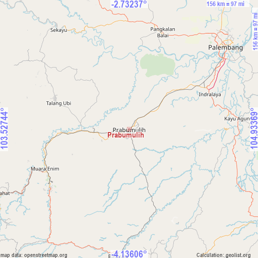
Prabumulih GPS coordinates[2]
3° 26' 4.092" South, 104° 13' 50.016" East
| Map corner | latitude | longitude |
|---|---|---|
| Upper-left | -2.73237°, | 103.52744° |
| Center: | -3.43447°, | 104.23056° |
| Lower-right: | -4.13606°, | 104.93369° |
| Map W x H: | 156.1×156.1 km | = 97×97mi |
| max Lat: | 5.88969° ⇑9.6% North |
| Prabumulih: | -3.43447° |
| min Lat: | ⇓90.4% South -10.934° |
| min Long | Prabumulih | max Long |
| 95.1345° | 104.23056° | 140.9419° |
| W 5%⇐ | ⇒95% E |
Elevation
Elevation of Prabumulih is 51 m = 167 ft, and this is 178.7 m = 586 ft below average elevation for this country.
| Max E: |
3185 m = 10449 ft | 62.1% |
| Avg. | 229.7 m = 754 ft | |
| Prabumulih | 51 m = 167 ft | |
Min E: |
-1 m = -3 ft | 37.9% |
See also: Prabumulih elevation on elevation.city.
Geographical zone
Prabumulih is located in South Torrid zone (between Equator and Tropic of Capricorn). Distance of Equator is 381.9 km =237.3 mi to North.| Distance of | km | miles | from Prabumulih |
|---|---|---|---|
| Equator | 381.9 | 237.3 | to North |
| Tropic Capricorn | 2224 | 1381.9 | to South |
| Antarctic Circle | 7019.3 | 4361.6 | to South |
| South Pole | 9625.2 | 5980.8 | to South |


Nearby cities:
15 places around Prabumulih: (largest is in red/bold)
• Cempaka
58.7 km =36.5 mi,  124°
124°
• Glumbang
31.6 km =19.6 mi,  46°
46°
• Gunungmegang Dalam
40.1 km =24.9 mi,  267°
267°
• Gunungmenang
35.8 km =22.2 mi,  322°
322°
• Indralaya
53.4 km =33.2 mi,  67°
67°
• Kayu Agung
66.8 km =41.5 mi,  85°
85°
• Muara Enim
56.3 km =35 mi,  244°
244°
• Muarakuang
45.4 km =28.2 mi, 124°
• Pangkalan Balai
64.1 km =39.8 mi,  16°
16°
• Peninjawan
51.2 km =31.8 mi,  160°
160°
• Suban Jeriji
45.6 km =28.3 mi,  220°
220°
• Sungairotan
37.3 km =23.2 mi,  8°
8°
• Talang Ubi
48.7 km =30.3 mi,  292°
292°
• Tanjung Lubuk
59.5 km =37 mi,  99°
99°
• Tanjungraja
61.3 km =38.1 mi,  79°
79°
Sources, notices
• [Note1] Compared only with cities in Indonesia existing in our database
• [Src1] Map data: © OpenStreetMap contributors (CC-BY-SA)
• [Src2] Other city data from geonames.org with taken over terms of usage.
• [Src3] Geographical zone / Annual Mean Temperature by Robert A. Rohde @ Wikipedia
