Lebaksiu geodata
Lebaksiu (Central Java) is a populated place; located in Indonesia in Asia/Jakarta (GMT+7) time zone. With population of 33,606 people, there are 297 cities with bigger population in this country. Compared to other cities in Indonesia, 62.6% of cities are located further ↓South; 66.5% of cities are located further →East and 58.4% of cities have lower elevation than Lebaksiu. Note1


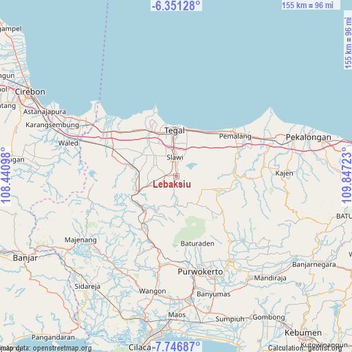
Lebaksiu GPS coordinates[2]
7° 2' 58.56" South, 109° 8' 38.76" East
| Map corner | latitude | longitude |
|---|---|---|
| Upper-left | -6.35128°, | 108.44098° |
| Center: | -7.0496°, | 109.1441° |
| Lower-right: | -7.74687°, | 109.84723° |
| Map W x H: | 155.2×155.2 km | = 96.4×96.4mi |
| max Lat: | 5.88969° ⇑37.4% North |
| Lebaksiu: | -7.0496° |
| min Lat: | ⇓62.6% South -10.934° |
| min Long | Lebaksiu | max Long |
| 95.1345° | 109.1441° | 140.9419° |
| W 33.5%⇐ | ⇒66.5% E |
Elevation
Elevation of Lebaksiu is 149 m = 489 ft, and this is 80.7 m = 265 ft below average elevation for this country.
| Max E: |
3185 m = 10449 ft | 41.6% |
| Avg. | 229.7 m = 754 ft | |
| Lebaksiu | 149 m = 489 ft | |
Min E: |
-1 m = -3 ft | 58.4% |
See also: Indonesia elevation on elevation.city.
Geographical zone
Lebaksiu is located in South Torrid zone (between Equator and Tropic of Capricorn). Distance of Equator is 783.8 km =487 mi to North.| Distance of | km | miles | from Lebaksiu |
|---|---|---|---|
| Equator | 783.8 | 487 | to North |
| Tropic Capricorn | 1822.1 | 1132.2 | to South |
| Antarctic Circle | 6617.3 | 4111.8 | to South |
| South Pole | 9223.2 | 5731 | to South |


Nearby cities:
15 places around Lebaksiu: (largest is in red/bold)
• Adiwerna
12.5 km =7.8 mi,  354°
354°
• Balapulang
4.8 km =3 mi,  271°
271°
• Baturaden
29 km =18 mi,  163°
163°
• Brebes
23.2 km =14.4 mi,  329°
329°
• Bulakamba
28.4 km =17.6 mi,  313°
313°
• Dukuhturi
17.9 km =11.1 mi,  338°
338°
• Kadumanis
33.6 km =20.9 mi,  245°
245°
• Ketanggungan
30.6 km =19 mi,  293°
293°
• Margasari
15.1 km =9.4 mi, 248°
• Pamedaran
30.9 km =19.2 mi, 266°
• Pemalang
31.6 km =19.6 mi,  56°
56°
• Randudongkal
20.6 km =12.8 mi,  105°
105°
• Slawi
7.6 km =4.7 mi,  357°
357°
• Tarub
13.2 km =8.2 mi,  10°
10°
• Tegal
20 km =12.4 mi, 358°
Sources, notices
• [Note1] Compared only with cities in Indonesia existing in our database
• [Src1] Map data: © OpenStreetMap contributors (CC-BY-SA)
• [Src2] Other city data from geonames.org with taken over terms of usage.
• [Src3] Geographical zone / Annual Mean Temperature by Robert A. Rohde @ Wikipedia
