Tarub geodata
Tarub (Central Java) is a populated place; located in Indonesia in Asia/Jakarta (GMT+7) time zone. With population of 75,739 people, there are 170 cities with bigger population in this country. Compared to other cities in Indonesia, 70.5% of cities are located further ↓South; 66.4% of cities are located further →East and 77.1% of cities have higher elevation than Tarub. Note1


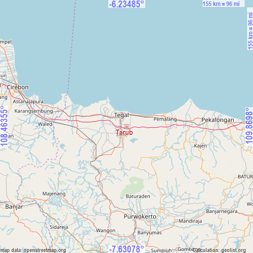
Tarub GPS coordinates[2]
6° 55' 59.988" South, 109° 10' 0.012" East
| Map corner | latitude | longitude |
|---|---|---|
| Upper-left | -6.23485°, | 108.46355° |
| Center: | -6.93333°, | 109.16667° |
| Lower-right: | -7.63078°, | 109.8698° |
| Map W x H: | 155.2×155.2 km | = 96.4×96.4mi |
| max Lat: | 5.88969° ⇑29.5% North |
| Tarub: | -6.93333° |
| min Lat: | ⇓70.5% South -10.934° |
| min Long | Tarub | max Long |
| 95.1345° | 109.16667° | 140.9419° |
| W 33.6%⇐ | ⇒66.4% E |
Elevation
Elevation of Tarub is 22 m = 72 ft, and this is 207.7 m = 681 ft below average elevation for this country.
| Max E: |
3185 m = 10449 ft | 77.1% |
| Avg. | 229.7 m = 754 ft | |
| Tarub | 22 m = 72 ft | |
Min E: |
-1 m = -3 ft | 22.9% |
See also: Tarub elevation on elevation.city.
Geographical zone
Tarub is located in South Torrid zone (between Equator and Tropic of Capricorn). Distance of Equator is 770.9 km =479 mi to North.| Distance of | km | miles | from Tarub |
|---|---|---|---|
| Equator | 770.9 | 479 | to North |
| Tropic Capricorn | 1835 | 1140.2 | to South |
| Antarctic Circle | 6630.3 | 4119.9 | to South |
| South Pole | 9236.1 | 5739 | to South |


Nearby cities:
15 places around Tarub: (largest is in red/bold)
• Adiwerna
3.8 km =2.4 mi,  262°
262°
• Balapulang
14.7 km =9.1 mi,  209°
209°
• Brebes
15.9 km =9.9 mi,  296°
296°
• Bulakamba
24.2 km =15 mi,  285°
285°
• Dukuhkopi
37.4 km =23.2 mi, 256°
• Dukuhturi
9.9 km =6.2 mi, 291°
• Ketanggungan
30.4 km =18.9 mi,  268°
268°
• Lebaksiu
13.2 km =8.2 mi,  190°
190°
• Margasari
24.8 km =15.4 mi,  221°
221°
• Melahayu
38.9 km =24.2 mi,  254°
254°
• Pamedaran
36.5 km =22.7 mi, 245°
• Pemalang
24.3 km =15.1 mi,  79°
79°
• Randudongkal
25.3 km =15.7 mi,  136°
136°
• Slawi
6.1 km =3.8 mi, 208°
• Tegal
7.7 km =4.8 mi,  337°
337°
Sources, notices
• [Note1] Compared only with cities in Indonesia existing in our database
• [Src1] Map data: © OpenStreetMap contributors (CC-BY-SA)
• [Src2] Other city data from geonames.org with taken over terms of usage.
• [Src3] Geographical zone / Annual Mean Temperature by Robert A. Rohde @ Wikipedia
