Labuan Bajo geodata
Labuan Bajo (East Nusa Tenggara) is a seat of a second-order administrative division; located in Indonesia in Asia/Makassar (GMT+8) time zone. With population of 188,724 people, there are 57 cities with bigger population in this country. Compared to other cities in Indonesia, 83.3% of cities are located further ↑North; 82.4% of cities are located further ←West and 59.1% of cities have higher elevation than Labuan Bajo. Note1


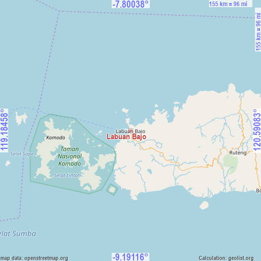
Labuan Bajo GPS coordinates[2]
8° 29' 47.04" South, 119° 53' 15.72" East
| Map corner | latitude | longitude |
|---|---|---|
| Upper-left | -7.80038°, | 119.18458° |
| Center: | -8.4964°, | 119.8877° |
| Lower-right: | -9.19116°, | 120.59083° |
| Map W x H: | 154.6×154.6 km | = 96.1×96.1mi |
| max Lat: | 5.88969° ⇑83.3% North |
| Labuan Bajo: | -8.4964° |
| min Lat: | ⇓16.7% South -10.934° |
| min Long | Labuan Bajo | max Long |
| 95.1345° | 119.8877° | 140.9419° |
| W 82.4%⇐ | ⇒17.6% E |
Elevation
Elevation of Labuan Bajo is 63 m = 207 ft, and this is 166.7 m = 547 ft below average elevation for this country.
| Max E: |
3185 m = 10449 ft | 59.1% |
| Avg. | 229.7 m = 754 ft | |
| Labuan Bajo | 63 m = 207 ft | |
Min E: |
-1 m = -3 ft | 40.9% |
See also: Labuan Bajo elevation on elevation.city.
Geographical zone
Labuan Bajo is located in South Torrid zone (between Equator and Tropic of Capricorn). Distance of Equator is 944.7 km =587 mi to North.| Distance of | km | miles | from Labuan Bajo |
|---|---|---|---|
| Equator | 944.7 | 587 | to North |
| Tropic Capricorn | 1661.2 | 1032.2 | to South |
| Antarctic Circle | 6456.5 | 4011.9 | to South |
| South Pole | 9062.4 | 5631.1 | to South |


Nearby cities:
15 places around Labuan Bajo: (largest is in red/bold)
• Betong
17.8 km =11.1 mi,  97°
97°
• Bolengpulau
13.4 km =8.3 mi,  61°
61°
• Cempa
1.1 km =0.7 mi,  289°
289°
• Dalong
9.3 km =5.8 mi,  145°
145°
• Golondalas
18 km =11.2 mi,  127°
127°
• Kenari
14.5 km =9 mi,  201°
201°
• Mberheleng
19.7 km =12.2 mi, 95°
• Melo
13.9 km =8.6 mi,  144°
144°
• Merombok
5 km =3.1 mi,  168°
168°
• Mesa
16 km =9.9 mi,  257°
257°
• Ndewel
20.2 km =12.6 mi,  118°
118°
• Rungkam
11.5 km =7.1 mi,  77°
77°
• Tohong
14.4 km =8.9 mi, 118°
• Waewaso
1.2 km =0.7 mi, 56°
• Wangkung
13.5 km =8.4 mi, 99°
Sources, notices
• [Note1] Compared only with cities in Indonesia existing in our database
• [Src1] Map data: © OpenStreetMap contributors (CC-BY-SA)
• [Src2] Other city data from geonames.org with taken over terms of usage.
• [Src3] Geographical zone / Annual Mean Temperature by Robert A. Rohde @ Wikipedia
