Ndewel geodata
Ndewel (East Nusa Tenggara) is a seat of a fourth-order administrative division; located in Indonesia in Asia/Makassar (GMT+8) time zone. In our database, there are 407 cities with bigger population. Compared to other cities in Indonesia, 86.5% of cities are located further ↑North; 82.8% of cities are located further ←West and 86.5% of cities have lower elevation than Ndewel. Note1


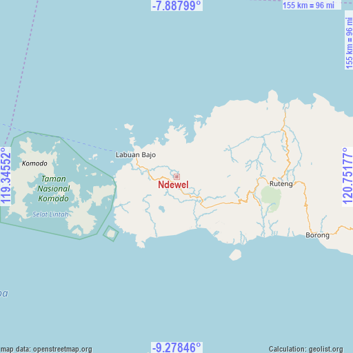
Ndewel GPS coordinates[2]
8° 35' 1.896" South, 120° 2' 55.104" East
| Map corner | latitude | longitude |
|---|---|---|
| Upper-left | -7.88799°, | 119.34552° |
| Center: | -8.58386°, | 120.04864° |
| Lower-right: | -9.27846°, | 120.75177° |
| Map W x H: | 154.6×154.6 km | = 96.1×96.1mi |
| max Lat: | 5.88969° ⇑86.5% North |
| Ndewel: | -8.58386° |
| min Lat: | ⇓13.5% South -10.934° |
| min Long | Ndewel | max Long |
| 95.1345° | 120.04864° | 140.9419° |
| W 82.8%⇐ | ⇒17.2% E |
Elevation
Elevation of Ndewel is 546 m = 1791 ft, and this is 316.3 m = 1038 ft above average elevation for this country.
| Max E: |
3185 m = 10449 ft | 13.5% |
| Ndewel | 546 m 1791 ft | |
| Avg. | 229.7 m = 754 ft | |
Min E: |
-1 m = -3 ft | 86.5% |
See also: Indonesia elevation on elevation.city.
Geographical zone
Ndewel is located in South Torrid zone (between Equator and Tropic of Capricorn). Distance of Equator is 954.4 km =593 mi to North.| Distance of | km | miles | from Ndewel |
|---|---|---|---|
| Equator | 954.4 | 593 | to North |
| Tropic Capricorn | 1651.5 | 1026.2 | to South |
| Antarctic Circle | 6446.7 | 4005.8 | to South |
| South Pole | 9052.6 | 5625 | to South |


Nearby cities:
15 places around Ndewel: (largest is in red/bold)
• Bambor
3.4 km =2.1 mi,  158°
158°
• Betong
7.5 km =4.7 mi,  0°
0°
• Dahot
7.5 km =4.7 mi, 159°
• Golondalas
3.5 km =2.2 mi,  251°
251°
• Handeng
11.3 km =7 mi,  57°
57°
• Lando
10.3 km =6.4 mi,  19°
19°
• Mberheleng
8.2 km =5.1 mi,  13°
13°
• Melo
9.7 km =6 mi,  260°
260°
• Rambang
7.1 km =4.4 mi,  182°
182°
• Ranggawatu
3.2 km =2 mi,  188°
188°
• Teongtoda
8.2 km =5.1 mi,  216°
216°
• Tohong
5.8 km =3.6 mi,  300°
300°
• Tondongraja
1.1 km =0.7 mi,  86°
86°
• Wangkung
8.7 km =5.4 mi,  330°
330°
• Werang
8.3 km =5.2 mi,  210°
210°
Sources, notices
• [Note1] Compared only with cities in Indonesia existing in our database
• [Src1] Map data: © OpenStreetMap contributors (CC-BY-SA)
• [Src2] Other city data from geonames.org with taken over terms of usage.
• [Src3] Geographical zone / Annual Mean Temperature by Robert A. Rohde @ Wikipedia
