Melo geodata
Melo (East Nusa Tenggara) is a seat of a fourth-order administrative division; located in Indonesia in Asia/Makassar (GMT+8) time zone. In our database, there are 407 cities with bigger population. Compared to other cities in Indonesia, 86.8% of cities are located further ↑North; 82.6% of cities are located further ←West and 86.7% of cities have lower elevation than Melo. Note1


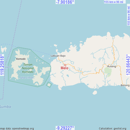
Melo GPS coordinates[2]
8° 35' 51.72" South, 119° 57' 40.68" East
| Map corner | latitude | longitude |
|---|---|---|
| Upper-left | -7.90186°, | 119.25818° |
| Center: | -8.5977°, | 119.9613° |
| Lower-right: | -9.29227°, | 120.66443° |
| Map W x H: | 154.6×154.6 km | = 96.1×96.1mi |
| max Lat: | 5.88969° ⇑86.8% North |
| Melo: | -8.5977° |
| min Lat: | ⇓13.2% South -10.934° |
| min Long | Melo | max Long |
| 95.1345° | 119.9613° | 140.9419° |
| W 82.6%⇐ | ⇒17.4% E |
Elevation
Elevation of Melo is 551 m = 1808 ft, and this is 321.3 m = 1054 ft above average elevation for this country.
| Max E: |
3185 m = 10449 ft | 13.3% |
| Melo | 551 m 1808 ft | |
| Avg. | 229.7 m = 754 ft | |
Min E: |
-1 m = -3 ft | 86.7% |
See also: Indonesia elevation on elevation.city.
Geographical zone
Melo is located in South Torrid zone (between Equator and Tropic of Capricorn). Distance of Equator is 956 km =594 mi to North.| Distance of | km | miles | from Melo |
|---|---|---|---|
| Equator | 956 | 594 | to North |
| Tropic Capricorn | 1649.9 | 1025.2 | to South |
| Antarctic Circle | 6445.2 | 4004.9 | to South |
| South Pole | 9051.1 | 5624.1 | to South |


Nearby cities:
15 places around Melo: (largest is in red/bold)
• Bambor
11 km =6.8 mi,  98°
98°
• Betong
13.2 km =8.2 mi,  46°
46°
• Dahot
13.4 km =8.3 mi,  114°
114°
• Dalong
4.6 km =2.9 mi,  322°
322°
• Golondalas
6.2 km =3.9 mi,  86°
86°
• Kenari
13.5 km =8.4 mi,  260°
260°
• Merombok
9.5 km =5.9 mi,  311°
311°
• Ndewel
9.7 km =6 mi,  80°
80°
• Rambang
10.9 km =6.8 mi,  120°
120°
• Ranggawatu
9.3 km =5.8 mi, 99°
• Teongtoda
6.9 km =4.3 mi,  137°
137°
• Tohong
6.4 km =4 mi, 45°
• Tondongraja
10.8 km =6.7 mi, 81°
• Wangkung
10.5 km =6.5 mi,  30°
30°
• Werang
7.9 km =4.9 mi, 136°
Sources, notices
• [Note1] Compared only with cities in Indonesia existing in our database
• [Src1] Map data: © OpenStreetMap contributors (CC-BY-SA)
• [Src2] Other city data from geonames.org with taken over terms of usage.
• [Src3] Geographical zone / Annual Mean Temperature by Robert A. Rohde @ Wikipedia
