Golondalas geodata
Golondalas (East Nusa Tenggara) is a seat of a fourth-order administrative division; located in Indonesia in Asia/Makassar (GMT+8) time zone. In our database, there are 407 cities with bigger population. Compared to other cities in Indonesia, 86.7% of cities are located further ↑North; 82.7% of cities are located further ←West and 95.1% of cities have lower elevation than Golondalas. Note1


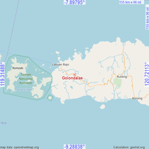
Golondalas GPS coordinates[2]
8° 35' 37.68" South, 120° 1' 4.8" East
| Map corner | latitude | longitude |
|---|---|---|
| Upper-left | -7.89795°, | 119.31488° |
| Center: | -8.5938°, | 120.018° |
| Lower-right: | -9.28838°, | 120.72113° |
| Map W x H: | 154.6×154.6 km | = 96.1×96.1mi |
| max Lat: | 5.88969° ⇑86.7% North |
| Golondalas: | -8.5938° |
| min Lat: | ⇓13.3% South -10.934° |
| min Long | Golondalas | max Long |
| 95.1345° | 120.018° | 140.9419° |
| W 82.7%⇐ | ⇒17.3% E |
Elevation
Elevation of Golondalas is 823 m = 2700 ft, and this is 593.3 m = 1947 ft above average elevation for this country.
| Max E: |
3185 m = 10449 ft | 4.9% |
| Golondalas | 823 m 2700 ft | |
| Avg. | 229.7 m = 754 ft | |
Min E: |
-1 m = -3 ft | 95.1% |
See also: Indonesia elevation on elevation.city.
Geographical zone
Golondalas is located in South Torrid zone (between Equator and Tropic of Capricorn). Distance of Equator is 955.5 km =593.7 mi to North.| Distance of | km | miles | from Golondalas |
|---|---|---|---|
| Equator | 955.5 | 593.7 | to North |
| Tropic Capricorn | 1650.4 | 1025.5 | to South |
| Antarctic Circle | 6445.6 | 4005.1 | to South |
| South Pole | 9051.5 | 5624.3 | to South |


Nearby cities:
15 places around Golondalas: (largest is in red/bold)
• Bambor
5 km =3.1 mi,  114°
114°
• Betong
9.3 km =5.8 mi,  21°
21°
• Dahot
8.4 km =5.2 mi,  134°
134°
• Dalong
9.6 km =6 mi,  289°
289°
• Lando
12.7 km =7.9 mi,  31°
31°
• Mberheleng
10.5 km =6.5 mi, 30°
• Melo
6.2 km =3.9 mi,  266°
266°
• Ndewel
3.5 km =2.2 mi,  71°
71°
• Rambang
6.8 km =4.2 mi,  152°
152°
• Ranggawatu
3.5 km =2.2 mi, 125°
• Teongtoda
5.7 km =3.5 mi,  195°
195°
• Tohong
4.4 km =2.7 mi,  338°
338°
• Tondongraja
4.6 km =2.9 mi,  75°
75°
• Wangkung
8.7 km =5.4 mi,  353°
353°
• Werang
6.2 km =3.9 mi,  187°
187°
Sources, notices
• [Note1] Compared only with cities in Indonesia existing in our database
• [Src1] Map data: © OpenStreetMap contributors (CC-BY-SA)
• [Src2] Other city data from geonames.org with taken over terms of usage.
• [Src3] Geographical zone / Annual Mean Temperature by Robert A. Rohde @ Wikipedia
