Komodo geodata
Komodo (East Nusa Tenggara) is a seat of a fourth-order administrative division; located in Indonesia in Asia/Makassar (GMT+8) time zone. With population of 2,000 people, there are 395 cities with bigger population in this country. Compared to other cities in Indonesia, 86.6% of cities are located further ↑North; 81.8% of cities are located further ←West and 93.7% of cities have higher elevation than Komodo. Note1


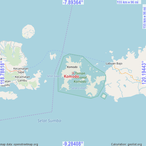
Komodo GPS coordinates[2]
8° 35' 22.2" South, 119° 29' 28.68" East
| Map corner | latitude | longitude |
|---|---|---|
| Upper-left | -7.89364°, | 118.78818° |
| Center: | -8.5895°, | 119.4913° |
| Lower-right: | -9.28408°, | 120.19443° |
| Map W x H: | 154.6×154.6 km | = 96.1×96.1mi |
| max Lat: | 5.88969° ⇑86.6% North |
| Komodo: | -8.5895° |
| min Lat: | ⇓13.4% South -10.934° |
| min Long | Komodo | max Long |
| 95.1345° | 119.4913° | 140.9419° |
| W 81.8%⇐ | ⇒18.2% E |
Elevation
Elevation of Komodo is 8 m = 26 ft, and this is 221.7 m = 727 ft below average elevation for this country.
| Max E: |
3185 m = 10449 ft | 93.7% |
| Avg. | 229.7 m = 754 ft | |
| Komodo | 8 m = 26 ft | |
Min E: |
-1 m = -3 ft | 6.3% |
See also: Indonesia elevation on elevation.city.
Geographical zone
Komodo is located in South Torrid zone (between Equator and Tropic of Capricorn). Distance of Equator is 955.1 km =593.5 mi to North.| Distance of | km | miles | from Komodo |
|---|---|---|---|
| Equator | 955.1 | 593.5 | to North |
| Tropic Capricorn | 1650.9 | 1025.8 | to South |
| Antarctic Circle | 6446.1 | 4005.4 | to South |
| South Pole | 9052 | 5624.7 | to South |


Nearby cities:
15 places around Komodo: (largest is in red/bold)
• Bombo
52.6 km =32.7 mi,  267°
267°
• Cempa
43.9 km =27.3 mi,  75°
75°
• Dalong
49 km =30.4 mi,  86°
86°
• Kenari
38.5 km =23.9 mi, 94°
• Kowo
53.7 km =33.4 mi,  276°
276°
• Labuan Bajo
44.8 km =27.8 mi, 76°
• Melo
51.7 km =32.1 mi, 91°
• Merombok
44.9 km =27.9 mi, 83°
• Mesa
28.8 km =17.9 mi, 76°
• Naebugis
53.3 km =33.1 mi, 271°
• Pataha
53.4 km =33.2 mi, 277°
• Poja Nae
50.7 km =31.5 mi, 281°
• Sigirato
52.7 km =32.7 mi, 266°
• Tao
38.2 km =23.7 mi,  106°
106°
• Waewaso
45.9 km =28.5 mi, 76°
Sources, notices
• [Note1] Compared only with cities in Indonesia existing in our database
• [Src1] Map data: © OpenStreetMap contributors (CC-BY-SA)
• [Src2] Other city data from geonames.org with taken over terms of usage.
• [Src3] Geographical zone / Annual Mean Temperature by Robert A. Rohde @ Wikipedia
