Tao geodata
Tao (East Nusa Tenggara) is a seat of a fourth-order administrative division; located in Indonesia in Asia/Makassar (GMT+8) time zone. In our database, there are 407 cities with bigger population. Compared to other cities in Indonesia, 89% of cities are located further ↑North; 82.4% of cities are located further ←West and 73.4% of cities have higher elevation than Tao. Note1


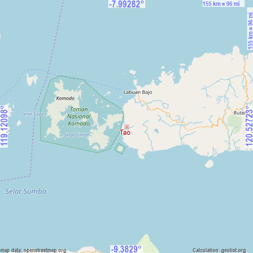
Tao GPS coordinates[2]
8° 41' 18.6" South, 119° 49' 26.76" East
| Map corner | latitude | longitude |
|---|---|---|
| Upper-left | -7.99282°, | 119.12098° |
| Center: | -8.6885°, | 119.8241° |
| Lower-right: | -9.3829°, | 120.52723° |
| Map W x H: | 154.6×154.6 km | = 96.1×96.1mi |
| max Lat: | 5.88969° ⇑89% North |
| Tao: | -8.6885° |
| min Lat: | ⇓11% South -10.934° |
| min Long | Tao | max Long |
| 95.1345° | 119.8241° | 140.9419° |
| W 82.4%⇐ | ⇒17.6% E |
Elevation
Elevation of Tao is 27 m = 89 ft, and this is 202.7 m = 665 ft below average elevation for this country.
| Max E: |
3185 m = 10449 ft | 73.4% |
| Avg. | 229.7 m = 754 ft | |
| Tao | 27 m = 89 ft | |
Min E: |
-1 m = -3 ft | 26.6% |
See also: Indonesia elevation on elevation.city.
Geographical zone
Tao is located in South Torrid zone (between Equator and Tropic of Capricorn). Distance of Equator is 966.1 km =600.3 mi to North.| Distance of | km | miles | from Tao |
|---|---|---|---|
| Equator | 966.1 | 600.3 | to North |
| Tropic Capricorn | 1639.8 | 1018.9 | to South |
| Antarctic Circle | 6435.1 | 3998.6 | to South |
| South Pole | 9041 | 5617.8 | to South |


Nearby cities:
15 places around Tao: (largest is in red/bold)
• Cempa
22.5 km =14 mi,  15°
15°
• Dalong
18.5 km =11.5 mi,  41°
41°
• Golondalas
23.8 km =14.8 mi,  63°
63°
• Kenari
8 km =5 mi,  12°
12°
• Labuan Bajo
22.5 km =14 mi, 18°
• Melo
18.1 km =11.2 mi, 56°
• Merombok
18.3 km =11.4 mi,  25°
25°
• Mesa
19.8 km =12.3 mi,  334°
334°
• Nangabere
21.1 km =13.1 mi,  132°
132°
• Nunang
20.1 km =12.5 mi,  100°
100°
• Rambang
24.8 km =15.4 mi,  79°
79°
• Teongtoda
20.4 km =12.7 mi, 75°
• Tohong
24.5 km =15.2 mi,  53°
53°
• Waewaso
23.4 km =14.5 mi, 19°
• Werang
21 km =13 mi, 77°
Sources, notices
• [Note1] Compared only with cities in Indonesia existing in our database
• [Src1] Map data: © OpenStreetMap contributors (CC-BY-SA)
• [Src2] Other city data from geonames.org with taken over terms of usage.
• [Src3] Geographical zone / Annual Mean Temperature by Robert A. Rohde @ Wikipedia
