Kerang geodata
Kerang (East Kalimantan) is a seat of a third-order administrative division; located in Indonesia in Asia/Makassar (GMT+8) time zone. In our database, there are 407 cities with bigger population. Compared to other cities in Indonesia, 92.6% of cities are located further ↓South; 75.9% of cities are located further ←West and 76.2% of cities have higher elevation than Kerang. Note1


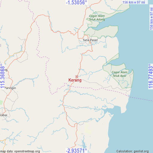
Kerang GPS coordinates[2]
2° 13' 59.88" South, 116° 4' 18.48" East
| Map corner | latitude | longitude |
|---|---|---|
| Upper-left | -1.53056°, | 115.36868° |
| Center: | -2.2333°, | 116.0718° |
| Lower-right: | -2.93571°, | 116.77493° |
| Map W x H: | 156.2×156.2 km | = 97.1×97.1mi |
| max Lat: | 5.88969° ⇑7.4% North |
| Kerang: | -2.2333° |
| min Lat: | ⇓92.6% South -10.934° |
| min Long | Kerang | max Long |
| 95.1345° | 116.0718° | 140.9419° |
| W 75.9%⇐ | ⇒24.1% E |
Elevation
Elevation of Kerang is 23 m = 75 ft, and this is 206.7 m = 678 ft below average elevation for this country.
| Max E: |
3185 m = 10449 ft | 76.2% |
| Avg. | 229.7 m = 754 ft | |
| Kerang | 23 m = 75 ft | |
Min E: |
-1 m = -3 ft | 23.8% |
See also: Indonesia elevation on elevation.city.
Geographical zone
Kerang is located in South Torrid zone (between Equator and Tropic of Capricorn). Distance of Equator is 248.3 km =154.3 mi to North.| Distance of | km | miles | from Kerang |
|---|---|---|---|
| Equator | 248.3 | 154.3 | to North |
| Tropic Capricorn | 2357.6 | 1464.9 | to South |
| Antarctic Circle | 7152.9 | 4444.6 | to South |
| South Pole | 9758.7 | 6063.8 | to South |


Nearby cities:
15 places around Kerang: (largest is in red/bold)
• Awayan
53 km =32.9 mi,  241°
241°
• Bakau
27.1 km =16.8 mi,  136°
136°
• Batusopang
48.9 km =30.4 mi,  338°
338°
• Gunungbatubesar
49.6 km =30.8 mi,  150°
150°
• Halong
46.8 km =29.1 mi,  266°
266°
• Juai
57.2 km =35.5 mi,  262°
262°
• Kuaro
46 km =28.6 mi,  1°
1°
• Lampihung
62.6 km =38.9 mi,  254°
254°
• Manunggulama
32.9 km =20.4 mi,  161°
161°
• Muarauya
65.5 km =40.7 mi,  305°
305°
• Mungkuruyam
55.2 km =34.3 mi, 266°
• Paringin
67.3 km =41.8 mi, 260°
• Putatbasiun
63.8 km =39.6 mi, 250°
• Tana Paser
38.8 km =24.1 mi,  19°
19°
• Tanjungsamalantakan
54 km =33.6 mi, 135°
Sources, notices
• [Note1] Compared only with cities in Indonesia existing in our database
• [Src1] Map data: © OpenStreetMap contributors (CC-BY-SA)
• [Src2] Other city data from geonames.org with taken over terms of usage.
• [Src3] Geographical zone / Annual Mean Temperature by Robert A. Rohde @ Wikipedia
