Kediri geodata
Kediri (East Java) is a populated place; located in Indonesia in Asia/Jakarta (GMT+7) time zone. With population of 235,143 people, there are 42 cities with bigger population in this country. Compared to other cities in Indonesia, 61% of cities are located further ↑North; 50.2% of cities are located further ←West and 56.8% of cities have higher elevation than Kediri. Note1


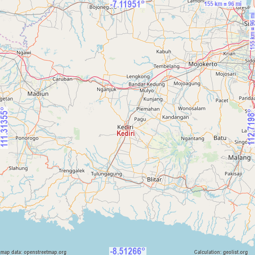
Kediri GPS coordinates[2]
7° 49' 0.012" South, 112° 1' 0.012" East
| Map corner | latitude | longitude |
|---|---|---|
| Upper-left | -7.11951°, | 111.31355° |
| Center: | -7.81667°, | 112.01667° |
| Lower-right: | -8.51266°, | 112.7198° |
| Map W x H: | 154.9×154.9 km | = 96.3×96.3mi |
| max Lat: | 5.88969° ⇑61% North |
| Kediri: | -7.81667° |
| min Lat: | ⇓39% South -10.934° |
| min Long | Kediri | max Long |
| 95.1345° | 112.01667° | 140.9419° |
| W 50.2%⇐ | ⇒49.8% E |
Elevation
Elevation of Kediri is 74 m = 243 ft, and this is 155.7 m = 511 ft below average elevation for this country.
| Max E: |
3185 m = 10449 ft | 56.8% |
| Avg. | 229.7 m = 754 ft | |
| Kediri | 74 m = 243 ft | |
Min E: |
-1 m = -3 ft | 43.2% |
See also: Kediri elevation on elevation.city.
Geographical zone
Kediri is located in South Torrid zone (between Equator and Tropic of Capricorn). Distance of Equator is 869.1 km =540 mi to North.| Distance of | km | miles | from Kediri |
|---|---|---|---|
| Equator | 869.1 | 540 | to North |
| Tropic Capricorn | 1736.8 | 1079.2 | to South |
| Antarctic Circle | 6532 | 4058.8 | to South |
| South Pole | 9137.9 | 5678 | to South |


Nearby cities:
15 places around Kediri: (largest is in red/bold)
• Gampengrejo
5.6 km =3.5 mi,  0°
0°
• Karangrejo
23.9 km =14.9 mi,  209°
209°
• Ngamba
22.3 km =13.9 mi,  188°
188°
• Ngantru
23.7 km =14.7 mi, 205°
• Ngasem
2.9 km =1.8 mi,  65°
65°
• Ngasinan
23.6 km =14.7 mi,  203°
203°
• Ngrawan
24.5 km =15.2 mi, 189°
• Pakel
23.9 km =14.9 mi, 210°
• Pare
20.7 km =12.9 mi, 74°
• Pulerejo
22.3 km =13.9 mi, 201°
• Salam
23.7 km =14.7 mi, 190°
• Tambakrejo
22.4 km =13.9 mi, 194°
• Tawangrejo
24.5 km =15.2 mi, 185°
• Tebokan
23.9 km =14.9 mi, 208°
• Temenggungan
20.9 km =13 mi, 190°
Sources, notices
• [Note1] Compared only with cities in Indonesia existing in our database
• [Src1] Map data: © OpenStreetMap contributors (CC-BY-SA)
• [Src2] Other city data from geonames.org with taken over terms of usage.
• [Src3] Geographical zone / Annual Mean Temperature by Robert A. Rohde @ Wikipedia
