Pare geodata
Pare (East Java) is a populated place; located in Indonesia in Asia/Jakarta (GMT+7) time zone. With population of 56,699 people, there are 211 cities with bigger population in this country. Compared to other cities in Indonesia, 60.6% of cities are located further ↑North; 51.5% of cities are located further ←West and 57.4% of cities have lower elevation than Pare. Note1


Pare GPS coordinates[2]
7° 46' 4.44" South, 112° 11' 52.8" East
| Map corner | latitude | longitude |
|---|---|---|
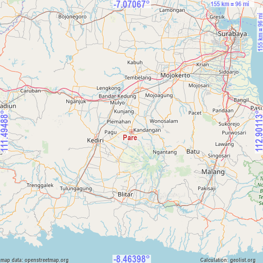
| Upper-left | -7.07067°, | 111.49488° |
| Center: | -7.7679°, | 112.198° |
| Lower-right: | -8.46398°, | 112.90113° |
| Map W x H: | 154.9×154.9 km | = 96.3×96.3mi |
| max Lat: | 5.88969° ⇑60.6% North |
| Pare: | -7.7679° |
| min Lat: | ⇓39.4% South -10.934° |
| min Long | Pare | max Long |
| 95.1345° | 112.198° | 140.9419° |
| W 51.5%⇐ | ⇒48.5% E |
Elevation
Elevation of Pare is 141 m = 463 ft, and this is 88.7 m = 291 ft below average elevation for this country.
| Max E: |
3185 m = 10449 ft | 42.6% |
| Avg. | 229.7 m = 754 ft | |
| Pare | 141 m = 463 ft | |
Min E: |
-1 m = -3 ft | 57.4% |
See also: Pare elevation on elevation.city.
Geographical zone
Pare is located in South Torrid zone (between Equator and Tropic of Capricorn). Distance of Equator is 863.7 km =536.7 mi to North.| Distance of | km | miles | from Pare |
|---|---|---|---|
| Equator | 863.7 | 536.7 | to North |
| Tropic Capricorn | 1742.2 | 1082.6 | to South |
| Antarctic Circle | 6537.5 | 4062.2 | to South |
| South Pole | 9143.4 | 5681.4 | to South |


Nearby cities:
15 places around Pare: (largest is in red/bold)
• Diwek
21.3 km =13.2 mi,  9°
9°
• Gampengrejo
20 km =12.4 mi,  270°
270°
• Gandusari
33 km =20.5 mi,  159°
159°
• Jombang
25 km =15.5 mi, 8°
• Kediri
20.7 km =12.9 mi,  254°
254°
• Kertosono
23.2 km =14.4 mi,  332°
332°
• Mojoagung
27.9 km =17.3 mi,  36°
36°
• Ngasem
17.8 km =11.1 mi,  256°
256°
• Ngoro
11.4 km =7.1 mi, 35°
• Purwosari
32.7 km =20.3 mi, 155°
• Ringinrejo
28.6 km =17.8 mi,  167°
167°
• Slumbung
31.6 km =19.6 mi,  149°
149°
• Sukosewu Satu
32.4 km =20.1 mi, 160°
• Sumberagung Satu
32.2 km =20 mi, 164°
• Wonosari
31.5 km =19.6 mi, 147°
Sources, notices
• [Note1] Compared only with cities in Indonesia existing in our database
• [Src1] Map data: © OpenStreetMap contributors (CC-BY-SA)
• [Src2] Other city data from geonames.org with taken over terms of usage.
• [Src3] Geographical zone / Annual Mean Temperature by Robert A. Rohde @ Wikipedia
