Bogor geodata
Bogor (West Java) is a populated place; located in Indonesia in Asia/Jakarta (GMT+7) time zone. With population of 800,000 people, there are 15 cities with bigger population in this country. Compared to other cities in Indonesia, 82.7% of cities are located further ↓South; 86.4% of cities are located further →East and 66.5% of cities have lower elevation than Bogor. Note1


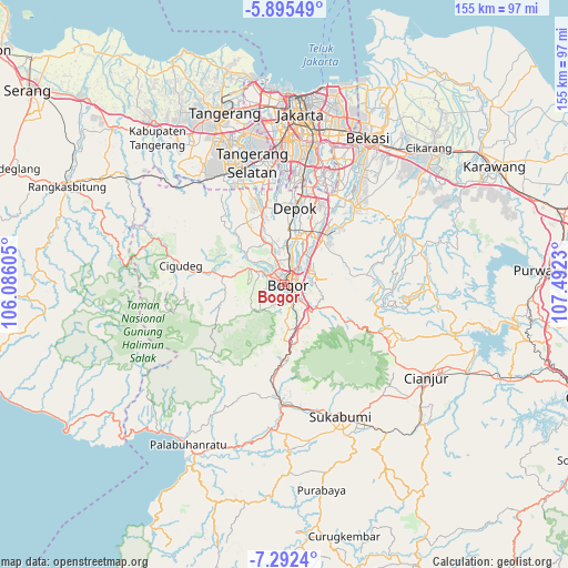
Bogor GPS coordinates[2]
6° 35' 39.984" South, 106° 47' 21.012" East
| Map corner | latitude | longitude |
|---|---|---|
| Upper-left | -5.89549°, | 106.08605° |
| Center: | -6.59444°, | 106.78917° |
| Lower-right: | -7.2924°, | 107.4923° |
| Map W x H: | 155.3×155.3 km | = 96.5×96.5mi |
| max Lat: | 5.88969° ⇑17.3% North |
| Bogor: | -6.59444° |
| min Lat: | ⇓82.7% South -10.934° |
| min Long | Bogor | max Long |
| 95.1345° | 106.78917° | 140.9419° |
| W 13.6%⇐ | ⇒86.4% E |
Elevation
Elevation of Bogor is 245 m = 804 ft, and this is 15.3 m = 50 ft above average elevation for this country.
| Max E: |
3185 m = 10449 ft | 33.5% |
| Bogor | 245 m 804 ft | |
| Avg. | 229.7 m = 754 ft | |
Min E: |
-1 m = -3 ft | 66.5% |
See also: Bogor elevation on elevation.city.
Geographical zone
Bogor is located in South Torrid zone (between Equator and Tropic of Capricorn). Distance of Equator is 733.2 km =455.6 mi to North.| Distance of | km | miles | from Bogor |
|---|---|---|---|
| Equator | 733.2 | 455.6 | to North |
| Tropic Capricorn | 1872.7 | 1163.6 | to South |
| Antarctic Circle | 6667.9 | 4143.2 | to South |
| South Pole | 9273.8 | 5762.5 | to South |


Nearby cities:
15 places around Bogor: (largest is in red/bold)
• Caringin
12.9 km =8 mi,  164°
164°
• Ciampea
10.7 km =6.6 mi,  294°
294°
• Cibinong
14.4 km =8.9 mi,  29°
29°
• Cicurug
20.8 km =12.9 mi,  182°
182°
• Cileungsir
29.1 km =18.1 mi,  40°
40°
• Cipatat
32.6 km =20.3 mi,  264°
264°
• Cipeundeuy
32.6 km =20.3 mi, 257°
• Citeureup
15.9 km =9.9 mi, 40°
• Depok
21.9 km =13.6 mi,  8°
8°
• Kadaka
33 km =20.5 mi,  284°
284°
• Kompa Satu
31.3 km =19.4 mi,  272°
272°
• Pamulang
28.5 km =17.7 mi,  348°
348°
• Parung
20.2 km =12.6 mi,  342°
342°
• Sawangan
21.4 km =13.3 mi,  355°
355°
• Sidoger Lebak
30.5 km =19 mi, 270°
Sources, notices
• [Note1] Compared only with cities in Indonesia existing in our database
• [Src1] Map data: © OpenStreetMap contributors (CC-BY-SA)
• [Src2] Other city data from geonames.org with taken over terms of usage.
• [Src3] Geographical zone / Annual Mean Temperature by Robert A. Rohde @ Wikipedia
